You are here
Assessing coastal climate risks at a local scale
Identifying climate change risk at a local scale is an important step in planning for adaptation. CoastAdapt provides guidance and tools for conducting different types of risk assessment.
At a glance
- Climate change risks will vary greatly from place to place. A local-scale climate change risk assessment is useful because it can take account of the unique characteristics of an area.
- The CoastAdapt decision support framework C-CADS (Coastal Climate Adaptation Decision Support) provides information and support for local-scale risk assessment.
- C-CADS identifies three levels of assessment.
- A first-pass assessment is a quick and straightforward way to get an overview of exposure to climate change risk.
- A second-pass assessment takes a standard risk assessment approach based on readily available information and expert knowledge.
- A detailed (third-pass) assessment is useful where the first- and second-pass assessments identify a potentially high risk. It involves the evaluation of fine-scale and targeted information and data. This step involves data gathering, which may be costly, and typically involves contracting a specialist consultant(s).
Main text
A local-scale climate change risk assessment: do I need it?
The climate change risks that a community may face vary greatly from place to place. For example, coastal flooding due to sea-level rise, and its consequences, will vary geographically, based on the unique characteristics of an area (e.g. climatic, coastal, geomorphic, demographic, economic and other factors).
A local-scale climate change risk assessment can take these unique characteristics into account. It will identify how climate change may impact on existing circumstances and land uses or create new risks. In particular, a local-scale risk assessment will:
- Identify which part(s) of a local community, services, businesses or natural ecosystems might be at risk. An example could be the operation of a council-owned water purification plant or sewage works or the delivery services of a small manufacturing enterprise.
- Provide a more detailed understanding of the climate risks specific to the area of interest. Is the sewage/water purification works located in a coastal zone that is prone to erosion? Do the routes followed by the delivery trucks run through low-lying wetlands likely to flood in a storm surge event?
- Support understanding of how disruption of the at-risk components can affect the services that they provide. What are the consequences of disruption of the operation of the sewage/water purification works – how many people will be affected, where do they live, how long will it take to restore services? What will be the financial losses to the business if deliveries are interrupted?
- Identify important coastal ecosystems and their potential vulnerability and ability to adapt to climate change impacts.
Local-scale climate change risk assessments aim to identify these issues and are useful to inform the adaptation planning of communities and organizations operating at the local scale. This approach is different from national- or regional-level assessments that address policy issues around, for example, overarching policies, national planning and financing of adaptation.
Identifying and assessing coastal climate change risks at a local scale
The CoastAdapt decision support framework C-CADS (Coastal Climate Adaptation Decision Support) can provide information and support to undertake a local-scale risk assessment, based around three levels of detail.
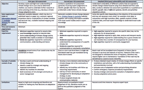
- A first-pass risk screening is a quick and straightforward way to get an overview of exposure to climate change risk. The goal is to establish whether the risk is large enough to warrant a more detailed assessment. This is especially appropriate for a resource-constrained organisation with limited data and information, as it may demonstrate that the risk is sufficiently small, or far in the future, that further investigation is not required or can be delayed. Conversely it may demonstrate that the resourcing of a more in-depth assessment is a priority. A first-pass assessment could be undertaken by a small in-house group using published information on climate change.
- A second-pass risk assessment takes a standard risk assessment approach and uses national data and locally available information and expert knowledge to identify how climate change may increase existing risks or create new ones. This differs from the first-pass approach in that it requires substantial input from appropriate experts, often through one or more workshops. These experts will need scenarios of future climate change, sea-level rise and coastal erosion vulnerability. These are generally available from websites such as Climate Change in Australia.
- A third-pass (detailed) risk assessment is appropriate where the first- and second-pass assessments indicate locations or sectors at high risk. Suppose the first- and second-pass assessments indicate a risk of more intense and more frequent rainstorms in future, that may flood the sewage/water purification works. In a detailed assessment, it is possible to obtain future daily rainfall data from a climate model, and use this as input to a hydrological model. The results from the hydrological model experiment would demonstrate quantitatively the extent to which the sewage works is at risk. The results from this approach would have to be interpreted with great care, taking into account all the uncertainties involved (see Understanding climate scenarios). This may involve a considerable cost and commitment and, where in-house expertise is not available, a consultant might be required to guide the process (see Using consultancies).
Table 1 provides more detail. CoastAdapt contains detailed guidelines and tools for these three levels of risk assessment (Link to Guidance on risk assessment and Risk assessment templates).
Data for a local-scale risk assessment
Often there is a preconception that a climate change risk assessment requires large amounts of data. In fact, the data requirements for a first- and second- pass assessment may be modest, and may simply require a little work to identify and access existing literature and data from existing websites and local expertise and experience. Only a detailed (third-pass) assessment would need data such as high-resolution digital elevation modelling, bathymetric information, downscaled local climate change and sea-level rise projection etc.
The data requirement depends on:
- The level of risk: where first- or second-pass assessments identify a high level of risk, then a detailed third-pass assessment may be necessary, requiring detailed data.
- The purpose of the assessment: detailed data may be required for a risk assessment that will influence engineering design criteria for a piece of critical infrastructure (e.g. a sea wall). However risk assessments that are intended to support community engagement and consultation as a first step in adaptation planning do not require detailed data, which may simply serve to confuse and alienate the audience (see Guidance on risk assessment).
There are a number of resources in CoastAdapt that discuss how to access and use data for understanding coastal climate risks:
- Present-day climate data sources
- Sediment compartments for coastal management:
- Understanding climate risks
- Accessing climate scenarios
- Data for risk assessment
- Information Manual 2: Available datasets
- Case study: Lakeside communities’ adaptation planning.
Table 1: Characteristics and requirements of local scale risk assessment approaches