


At a glance
- King Tide photo projects - held around the world, but no longer in Australia - help communities visualise future sea‑level rise by turning abstract climate projections into relatable images of real coastal flooding.
- Citizen scientists across regions such as Hawai‘i, the Pacific, New Zealand and California document extreme tides, creating visual records that support awareness, adaptation planning and validation of climate models.
- These initiatives strengthen community engagement, build shared understanding of coastal risk, and highlight how personal experience with flooding can motivate climate action.
- Successful projects rely on strong partnerships, accessible communication, emotional support for participants, and sustained funding to maintain long‑term impact.
- Safety guidance and inclusive outreach are essential to ensure diverse participation while protecting people, wildlife and sensitive coastal environments.
Snap the shore, see the future
It is often difficult for people to imagine a future that differs from their past experience. Although scientists widely agree that sea levels are rising, many people perceive the impacts as distant, either in time or location. Creative initiatives can help bridge this gap by making future scenarios more tangible, encouraging communities to plan for climate change.
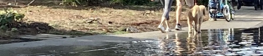
One such initiative invites citizens to photograph King Tides - the highest tides of the year - to illustrate what future coastal inundation might look like. Participants capture images of their local coastline during these extreme tides and upload them to a dedicated website, where the photos are displayed alongside an interactive map
These images are then uploaded to a website and displayed with links to a map (Figure 1). Such a collection of images of a very high tide is intended to develop a community narrative that could help people envisage what future coastal inundation might look like in familiar places. Research shows that personal experience with flooding often motivates individuals to take climate adaptation seriously, and these projects build on that insight.
Generally the images show both natural and built infrastructure with 'sunny day' or 'nuisance' flooding - temporary but inconvenient levels of inundation that cause little permanent damage - such as drenched jetties and walkways, or beaches covered up to the dunes with water.
By transforming abstract projections into relatable, place-based visuals, these projects aim to spark awareness and dialogue about climate resilience.
Broadly, the images are used to:
- observe, visualise and understand the impacts of future sea level rise on coastal communities
- help document current coastal flood risks in coastal areas
- ground-truth and validate climate change models by comparing model predictions with the high-tide reality
- serve as a living record of change for future generations.
Why use King tides?
King tides occur naturally within the tidal cycle. They occur for several days, a few times each year, when the gravitational pull of the sun, moon, and Earth align to produce exceptionally high tides.
While these events are not driven by climate change, the extreme water levels they create offer a preview of what rising seas could mean in the future. When king tides coincide with storms or flooding, water levels can surge even higher, posing a serious risk to coastlines and coastal infrastructure.
with a video from the Exploratorium that describes the science of King tides.
about how some King tides that cause 'sunny day' flooding may become more permanent flooding in the future
Hawaii and the Pacific snap King tides
The University of Hawai‘i Sea Grant College's 'Hawai‘i & Pacific Islands King Tides Project' that engages local residents across Hawaii and several other Pacific islands in documenting King tides to better understand impacts from sea-level rise and other coastal hazards.
A dedicated platform provided by Hawai‘i Sea Grant to upload photographs of coastal locations at their highest flood levels, along with date, time, and observations. The resulting photo database, accessible through an interactive web map, allows residents, researchers, and policymakers to visually explore flooding patterns across various Pacific locations, including Hawai‘i, Guam, American Samoa, and Majuro.
Key lessons from project outcomes.
- Make climate impacts tangible: People struggle to imagine future sea-level rise; visual tools like King Tide photos help make projections relatable.
- Community involvement matters: Citizen science builds local engagement and trust, turning abstract data into shared experiences.
- Visual storytelling is powerful: Photos of flooding influence public awareness, media coverage, and even policy discussions.
- Personal experience drives action: Seeing or experiencing flooding can motivate individuals to plan for climate change.
Key lessons for organising projects
- Extension agents are critical: Facilitators help translate science into accessible, community-friendly formats.
- Partnerships strengthen impact: Collaboration between scientists, local organisations, and residents enhances project reach and credibility.
- Emotional dimensions need attention: Participants often feel grief or anxiety about coastal change; projects should support emotional resilience.
- Equity and inclusion are challenges: Participation tends to be limited; targeted outreach is needed to engage diverse communities.
- Evaluation is essential: Systematic assessment of outcomes (behavior change, policy influence) is still lacking.
- Funding sustainability is a barrier: Long-term success requires stable resources for both research and outreach.
New Zealand snap King tides
There are two King tides projects in New Zealand Aotearoa:
- Northland (Whangārei region). This project by Northland Regional Council, King Tides Taitokerau, invites citizen scientists to photograph events on both east and west coasts.
- Auckland. The project, King Tides Auckland – Snap the Coast, See the Future, encourages locals to document king tides at city beaches, promenades, marinas, and waterfront infrastructure.
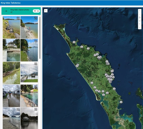
A map of sites where King Tide images have been taken.
- © Northland Regional Council.NZ King Tides map

A map of sites where King Tide images have been taken.
© Northland Regional Council.
The NZ project gives advice on "How to get the ‘shot’"
A mobile phone is fine to capture a photo on, and you can also upload it there and then to the website.Focus on featuring a reference point such as bridges, jetties, large trees, drains and roads alongside the water level.Take a look at low-lying areas you know are already prone to coastal flooding.Focus on beaches, estuaries and river/stream mouths and keep an eye out for erosion or waves reaching places it doesn’t usually get to.Please make sure your safety comes first when taking a photo. Remember “Nobody’s stronger than Tangaroa”. Keep a safe distance and an eye out for large waves, slippery surfaces and higher than normal water levels.Please also don't disturb shorebirds that may be much farther inland than usual, and always, keep off the dunes.
- A mobile phone is fine to capture a photo on, and you can also upload it there and then to the website.
- Focus on featuring a reference point such as bridges, jetties, large trees, drains and roads alongside the water level.
- Take a look at low-lying areas you know are already prone to coastal flooding.
- Focus on beaches, estuaries and river/stream mouths and keep an eye out for erosion or waves reaching places it doesn’t usually get to.
- Please make sure your safety comes first when taking a photo. Remember “Nobody’s stronger than Tangaroa”. Keep a safe distance and an eye out for large waves, slippery surfaces and higher than normal water levels.
- Please also don't disturb shorebirds that may be much farther inland than usual, and always, keep off the dunes.
California snaps King tides
The project in California is a statewide initiative led by the California Coastal Commission and partners. Key features include:
- public events during peak king tide dates (e.g., Dec 4–5, 2025; Jan 2–3, 2026), including 'After Dark' explorations and group outings in San Francisco, San Diego, Monterey, and Mendocino
- an interactive photo gallery, educator resources, smartphone app integration, and community-driven uploads of shoreline photos.
"Sharing your photos and talking about what you've noticed helps others understand that they're part of a community that cares about the climate crisis and wants to take action."
To cite:
This case study was prepared by NCCARF. Please cite as: NCCARF, 2025: King tides offer a glimpse of the future. Case study for CoastAdapt, National Climate Change Adaptation Research Facility, Griffith University, Gold Coast.