


At a glance
- Understanding coastal dynamics is essential for managing risks to communities, infrastructure, and ecosystems in a changing climate.
- The coast is a dynamic environment where the atmosphere, ocean, and land interact.
- Natural forces—waves, tides, currents, wind, and temperature—continuously shape and reshape the coastline, driving change across short, medium, and long timescales.
- Two common hazards are coastal erosion and inundation (coastal flooding).
- Coastal erosion occurs when wind, waves, and coastal currents move sediment away from the shoreline, often during storms. Erosion is temporary, and the shoreline gradually recovers as sediment is redeposited. However, it can be worsened by sea level rise or hard permanent structures.
- Inundation or coastal flooding:occurs during storms when low atmospheric pressure and strong onshore winds generate storm surge and extreme wave heights. Especially when combined with high tides, these conditions can cause significant flooding along the coast.
- Both hazards can result in property damage, environmental degradation, and even loss of life.
- Risks and impacts are greatest by development on soft sediment or low lying areas.
- Understanding these processes is critical for: coastal planning and infrastructure design, risk management and emergency preparedness, development of climate adaptation strategies to protect communities and ecosystems
The dynamic drivers of coastal change on sandy shores
The coast is a relatively narrow and dynamic zone shaped by complex interactions among oceanic, terrestrial, and atmospheric processes.
- Atmosphere, through rainfall and temperature, affects land weathering and sediment delivery; large scale systems influence sea levels. Temperature and large-scale atmospheric systems also influence sea levels.
- Oceanic forces such as waves, tides, currents, and ocean temperature provide energy that erodes and builds coastal landforms.
- Wind drives ocean currents and generates waves that both erode the coast and transport sediments onshore to form dunes.
Coastal change is a natural process occurring over various timescales.
- Long-term changes to the shoreline are driven by global climate shifts and geological activity, such as the approximately 120 m sea level rise since the last glacial maximum 20,000 years ago.
- Ongoing processes of sediment transport, which includes the supply of sediment from rivers, erosion, and offshore sources, as well as sediment transport redistribution by currents, waves, and wind.
- Short-term impacts, caused by extreme events such as severe tropical cyclones or East Coast Lows.
Human activities – such as urbanisation, industrial development, and recreation – have significantly altered the coastal zone. While some communities have natural or foreshore public reserves as buffers, many communities remain directly exposed to coastal hazards.
Understanding dynamic coastal processes, their interactions, and the factors that lead to inundation and erosion is critical for successful coastal planning and decision-making (Figure 1).

Figure 1: Coastal inundation and coastal erosion arise from intricate interactions between several drivers.
- Source: Adapted from New Zealand Ministry for the Environment 2004.#13_coastal dynamics
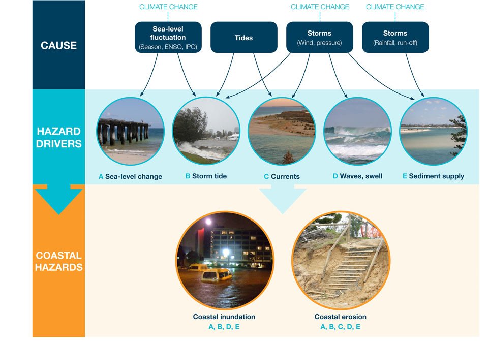
Figure 1: Coastal inundation and coastal erosion arise from intricate interactions between several drivers.
Source: Adapted from New Zealand Ministry for the Environment 2004.
Understanding coastal hazards
Coastal erosion and inundation are the primary hazards affecting shorelines when dynamic coastal processes intensify, often heightened by extreme weather events. These events can lead to severe property damage, environmental degradation, and, in extreme cases, loss of life. Impacts are most pronounced in areas where the coastline has been modified or developed for infrastructure and human settlements.
Erosion is a natural process that often occurs gradually through mechanisms such as longshore drift, which transports sand along the beach. However, both erosion and inundation can happen suddenly during extreme events like tropical cyclones and East Coast Lows, which bring strong winds, large waves, and coastal flooding.
Long-term changes, including sea-level rise driven by climate change, are projected to steadily increase the frequency and intensity of these hazards, making it important to plan for coastal risk management and adaptation.
about extreme weather events such as Tropical cyclones and East Coast Lows
Coastal erosion
Coastal erosion is a natural process that occurs when winds, waves and coastal currents act to shift sediments away from an area of the shore, often during storm events. In most locations this is a short-term process and the shore gradually regains sediment over timescales of weeks to months.
However, erosion can become a persistent problem where human activities have altered the coast. Structures such as breakwaters, groynes, and seawalls are commonly built to protect infrastructure, housing, or shipping channels. While these measures aim to reduce erosion, they harden the shoreline and limit its ability to adjust naturally, often creating new erosion issues elsewhere.
Examples include:
- The 1889 artificial opening of the Gippsland Lakes (Victoria) increased the flooding exposure of the Lakes Entrance settlement.
- The 1962-64 decision by the New South Wales government to extend seaward the Tweed River training walls to keep the river mouth navigable, which blocked the northward movement of sand to Queensland. This, combined with a series of severe cyclones in 1967, threatened homes, roads and businesses in the Gold Coast
- The development of housing more than 100 years ago at the erosion-prone Collaroy Beach in Sydney has led to buildings in the area being undermined with each major coastal storm. This was highlighted in June 2016 with a major erosion event that has since resulted in a sea wall being funded by local council and some directly homeowners.

UNSW drone survey of the damaged foreshore in Sydney's Collaroy Beach. Left: 1 June 2016. Right: 7 June 2016.
- © UNSW Water Research Lab#13_collaroy_before_and_after_1
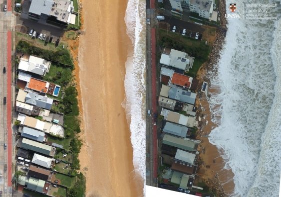
UNSW drone survey of the damaged foreshore in Sydney's Collaroy Beach. Left: 1 June 2016. Right: 7 June 2016.
© UNSW Water Research Lab
How structures affect longshore drift
Coastal structures can have a dramatic effect on the shape of a shoreline where there is longshore movement of sediment. Figure 2 shows that structures of any size can lead to erosion (red areas), and that accretion can occur updrift of the structure (brown areas), particularly where sediment movement is constrained.

Figure 2: Plan view of the effect of coastal structures on the shoreline.
- @ Damara WA Pty Ltd 2015#13_coastal dynamics fig 2
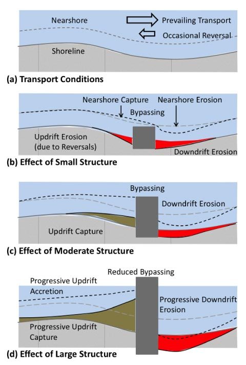
Figure 2: Plan view of the effect of coastal structures on the shoreline.
@ Damara WA Pty Ltd 2015
about coastal sediments and waves
As the climate changes, the models indicate that tropical cyclones will become less frequent but more intense, which may lead to greater coastal erosion in some areas.
In the medium to longer term, sea-level rise is also likely to lead to recession of unconsolidated shorelines, and in this case the loss of beaches will be permanent.
Coastal inundation
Coastal storm inundation is a natural phenomenon caused by the combined effects of two main factors. Strong onshore winds during a storm push seawater toward the shore, while low atmospheric pressure causes the ocean surface to rise. Together these cause a storm surge – a temporary rise in the sea as a result of wind and atmospheric pressure changes associated with a storm.
The severity of inundation depends on additional drivers, including:
- wave height
- coastal topography, such as dune height
- climate cycles, with La Niña raising sea levels and El Niño lowering them
- Timing, especially when storm surge coincides with high tide, producing a higher ‘storm tide’
Flooding can be further intensified when coastal rivers are in flood and cannot discharge to the ocean because of elevated sea levels. For example, during the 2022 Northern Rivers floods, a 1.8-metre king tide met the swollen Richmond River at Ballina, worsening inundation.
Human activities also amplify risk from storm inundation. Development in flood-prone areas, removal of natural barriers like dunes, and poorly designed coastal protection structures reduce resilience.
Coastal inundation hazards may also increase with sea-level rise linked to future climate change.
Examples include:
- In Ballina, Northern Rivers NSW, in 2022 a 1.8 m king tide met the swollen Richmond River as flood waters worked their way down from the upper catchment.
- In Townsville, North Queensland, in 2019, record-breaking rainfall caused severe flooding, and strong onshore winds pushed water into coastal areas. the drivers for this event was a prolonged monsoon trough, river flooding, and coastal surge, which amplified flooding and other impacts on low-lying suburbs.
In some locations, erosion becomes a chronic problem due to human intervention or development close to the shoreline.
Traditional protection works such as breakwaters, groynes and seawalls can harden the coast, interrupt longshore transport, t and create down‑drift erosion even as they protect specific sites.
Contemporary practice increasingly complements or replaces hard structures with nature‑based strategies (e.g., dune rehabilitation, wetland/mangrove restoration) and strategic planning tools, which may eventually include managed relocation, to better balance risk reduction and ecological function.
case studies in CoastAdapt about Trialling nature-based strategies.