You are here
Ask the Experts - Questions and Answers
There is a lot of information on the increased atmospheric CO2 pathway to ocean acidification and the impacts that can arise from that. However, at a more local level what impacts both positive and negative might be expected on seagrasses and microfauna from nourishment of beaches with sand that is slightly acidic (pH 5.5) versus an in-situ alkaline sand?
March 2017Answered by Alistair Hobday and Andrew Lenton, CSIRO Oceans and Atmosphere
Click to view answer
The effects of increased CO2 concentration on land plants have been shown to be positive in some cases, with growth rates increasing due to “CO2 fertilisation.” Seagrasses are marine flowering plants, and consequently may also grow better due to this fertilisation. However, the key issue in this question is whether nourishment of beaches with alkaline sand might reduce the impacts of ocean acidification, or with addition of relatively more acidic sand, might accelerate the effects.
Mitigation attempts, aimed at reducing the concentration of greenhouse gases entering the atmosphere, are considered the best approach to minimising ocean acidification. However, some intervention efforts may also modify the impacts of ocean acidification. For example, recent studies have suggested that the addition of sands made from finely crushed ultra-basic (alkaline) rocks such as fosterite and olivine have the potential to increase ocean pH, and enhance atmospheric CO2 uptake, thereby offsetting the impact of ocean acidification. This could be a dual benefit from beach nourishment, where sand with appropriate pH is added to beaches as part of restoration efforts, or to aid coastal protection, can also reduce impacts of ocean acidification.
While this input from “basic” (alkaline) sands can be considered as an acceleration of natural weathering processes, it is still a slow process that is estimated to take about 200 years to fully benefit the ocean. Whether the impacts would be felt locally (i.e. pH changes in local waters) would also depend on the residence times of waters in the coastal environment and the amount of sand added. Surface ocean waters are also in relative equilibrium with atmospheric concentrations of CO2, such that changes in pH concentration in shallow coastal water would quickly equilibrate with the atmosphere via outgassing or uptake of CO2.
This sand addition approach has been explored in places such as the Netherlands, where sand replenishment programs are ongoing with up to 1.2 million cubic metres/year being delivered to nearshore and beach sites.
It is also worth noting that the faster the pH changes, the larger the potential for negative impacts on the marine environment. The sourcing and energy cost of creating such alkaline sands may also be problematic. Strictly speaking, pH of 7 is neutral, pH above 7 is basic, and pH below 7 is acidic, thus ocean acidification is as much a process of water becoming less basic as it is a process of becoming more acidic. Additionally, the pH in coastal waters around Australia is now around 8.1 (i.e. alkaline), and most alkaline sands available in Australia already have a pH that is lower than seawater. Thus adding these sands might in fact further contribute to a reduction in pH, rather than increasing pH.
Overall, given the slow rates of sand weathering, coupled with water mixing and advection in the coastal ocean, sand addition effects on local pH and biota are unlikely, unless the right pH of sand is added in truly enormous volumes. These sands would have to come from land sources, because if they are already in the ocean, it would better to leave them where they are.
Additional reading
Montserrat et al (2017). Olivine Dissolution in Seawater: Implications for CO2 Sequestration through Enhanced Weathering in Coastal Environments. Env Sci & Tech. DOI: 10.1021/acs.est.6b05942
What are the pros and cons, and the relative cost-benefits, of retaining natural ecosystems (e.g. mangroves) versus restoration of these ecosystems once already removed, versus artificial structures such as seawalls in adapting to all the inundation problems associated with rising sea levels?
March 2017Answered by Garry Middle, VisionEnvironment Consulting
Click to view answer
This is a complex question and I’ll break it down into a few parts to answer it.
First, mangroves will have minimal impact on reducing inundation due to chronic – i.e. gradual and on-going – sea-level rise. Mangroves are best adapted to managing and reducing the impacts of acute inundation caused by storms and extreme tidal events. They are excellent in reducing the energy of waves, tidal surges and storm surges, and thus reducing the extent of the negative impacts of inundation to the adjacent land when severe events occur. Most mangroves in Australia are found in the tropical zones, which, under climate change, will likely experience more and stronger storm activity over time. Mangroves will certainly help in minimising the impacts of inundation caused by storm surges and large tidal events expected under climate change. As well, mangroves will also likely move further inland with rising sea levels.
Second, an additional complication is that mangroves are not immune to damage during storm events. As noted above, while mangroves do reduce the inundation impacts of storm events, storms cause loss of the mangroves, especially those bearing the brunt of the storm. It is likely that measures will need to be put in place to protect and actively manage mangroves as storm intensity increases over time. One study in Malaysia has used a submerged artificial reef to reduce the wave energy during storms to provide protection to a mangrove forest.
Third, where mangroves have been removed and replaced with human land uses – mostly urbanisation – the issue is more complex. These settlements, because of their proximity to the coast, provide a range of human use values – for example, aesthetic, recreational, property (economic), and tourism. As the impacts of climate change begin to be experienced in these areas – notably increased inundation – measures will need to be implemented in response. As suggested from the above, re-introducing mangroves to the coastal zone will help to reduce inundation due to extreme events, but this won’t stop the inundations due to chronic sea-level rise. Of course, re-introducing mangroves will impact on the human use values above as the coast is transformed from a highly accessible resource to a natural resource – i.e. natural values will be increased and human use values decreased.
An alternative to re-introducing mangroves is building near-shore artificial reefs that act to reduce the energy of the storm surges, tidal surges and waves. The design of these reefs needs to take into account that sea levels rise temporarily during storm events and that the deeper the water above the reef, the less effective the reef will be in reducing wave energy.
Seawalls are another alternative. They may well protect land adjacent to the beach from erosion, but will only provide protection from inundation if they are constructed high enough to deal with both acute events and chronic on-going sea-level rise.
The relative costs of re-introducing mangroves, building artificial reefs and seawalls are hard to determine, especially calculating the costs of re-introducing mangroves given the high number of factors that go into determining the success of the process. One estimate of the initial costs of re-introducing mangroves is US$500 per hectare, but ongoing costs are more difficult to determine. The size of a mangrove forest needed to protect a stretch of beach (length and width) is also difficult to determine.
The cost of reefs also varies depending on the material used, the height of the reef, and the area of constructed reef. For example, the construction cost of a reef to protect Palm Beach on the Gold Coast is around $20 million. This does not include on-going monitoring and maintenance costs. A 200m seawall constructed out of granite rocks in Dongara WA cost around $2 million, with an additional $290 000 spent in one year on repair and maintenance.
Fourth, in the long-term, rising sea levels and increased storm activity may well make defending most of these developed coasts both uneconomic and unviable no matter what method is used. Retreat from the coast may well be the only viable long-term option. Existing mangrove forests will naturally migrate inland, unless prevented from doing so – i.e. they will begin to encroach on private land.
In summary, mangroves will have minimal impact on reducing inundation due to chronic sea-level rise, but are best adapted to managing and reducing the impacts of acute inundation caused by storms and extreme tidal events. Other artificial measures – reefs and seawalls – can also minimise the impacts of acute inundation caused by storms and extreme tidal events. The initial economic costs of either re-introducing mangroves or building artificial measures are typically difficult to calculate, but all of these measures will require ongoing management, and these costs are difficult to calculate. Coasts where urban development has occurred and have had mangroves removed have lost significant natural values but have gained significant human-use values. Re-introducing mangroves will reverse this – i.e. significantly increase natural values at the cost of reduced human-use values. Artificial measures may protect existing human-use values in the short- to medium-term, and artificial reefs usually introduce additional ecological values. Ultimately, neither re-introducing mangroves nor building artificial measures on developed beaches are sustainable in the long-term in dealing with inundation due to on-going sea-level rise, and retreat may well be the only long-term option.
Fish species that are listed as endangered in NSW are turning up in Tasmania where they are not afforded the same level of protection. How are issues like this form of range extension going to be addressed?
February 2017Answered by Alistair Hobday, Senior Principal Research Scientist, CSIRO
Click to view answer
Given the increase in the number of fish species that are now reported out-of-range around Australia (e.g. RedMap (http://www.redmap.org.au/)), fisheries and conservation management do need to be proactive in managing range-expanding species. But movement of formally protected species is not a major management concern. Fisheries management has a range of options that are being explored or implemented.
In responding to this question, and considering climate-related changes in fish distribution, it is interesting to note the inconsistency of protected species status between State and Commonwealth levels, and between States. Species can be listed under State or Commonwealth legislation. Under the latter species are under the same protection level in any Australian jurisdiction. If a species is listed as protected in one state it may be under a different classification, or may not even be listed in another state.
What is the status of protection for marine fishes?
With regard to protected species, NSW has one species listed as critically endangered - the grey nurse shark (Carcharias taurus). The scalloped hammerhead shark (Sphyrna lewini) and southern bluefin tuna (SBT, Thunnus maccoyii) are listed as endangered, and the white shark (Carcharodon carcharias) and great hammerhead (Sphyrna mokarran) are listed as vulnerable.
Both listed species of hammerhead sharks are totally protected in NSW and cannot be taken by recreational or commercial fishers. In NSW, the recreational bag limit for the protected SBT is one per person per day, with commercial fishing prohibited inside NSW state waters (three nautical miles), although SBT are considered very rare inside state waters.
Other NSW species are protected from commercial fishing, such as the eastern blue groper (Achoerodus viridis), which has a daily bag limit of two fish above 30 cm (and only one above 60 cm) in NSW (see http://www.dpi.nsw.gov.au/__data/assets/pdf_file/0004/375880/Eastern-Blue-Groper.pdf), and can only be caught by line (e.g. not netted or speared). This species is likely to move south under climate change, but is already completely protected in Victoria (see http://agriculture.vic.gov.au/fisheries/recreational-fishing/recreational-fishing-guide/catch-limits-and-closed-seasons/marine-and-estuarine-scale-fish/blue-groper) and Tasmania (see http://dpipwe.tas.gov.au/sea-fishing-aquaculture/recreational-fishing/catch-limits/possession-limits-scalefish). Similarly, both white and grey nurse shark are already fully protected in Victoria: taking and possessing are prohibited. SBT is listed under Victoria’s Flora and Fauna Guarantee Act 1988 as a threatened species, although this species is more common in the south, where similar levels of protection may not be warranted. At an international level, SBT was listed as critically endangered in 1996, but is only considered conservation dependent at a national level (EPBC Act). Further south in Tasmania, the white and grey nurse sharks are already protected, as well as a number of other Tasmanian species. One Victorian protected species, the Black cod (Epinephelus daemelii), is not protected in Tasmania.
Using NSW as an example, the protected species are either: (i) tropical and likely to increase in NSW waters under climate change (e.g. hammerhead sharks), (ii) southern species that are already more common to the south (e.g. SBT), or (iii) NSW species that are already protected in other jurisdictions (e.g. grey nurse shark). On the basis of the above review, there do not appear to be many protected species that are likely to move from NSW to southern states where protection will be inadequate. On the west coast of Australia, fish range-change along the coast have also been recorded, but with regard to protected species status, this is obviously within the same jurisdiction.
The question in a more general sense raises some interesting issues (aside from protection status) that are not yet clearly resolved. What should be the management approach for fish species that become more common in a new jurisdiction?
Could a range-expanding species be listed for protection?
Yes: the usual listing process can be followed if there is a desire to seek protection for a range-expanding species in a new jurisdiction – however, to date there has not been a test of this listing approach for a range-expanding species. It is not clear that range-expanding species would meet the criteria for listing under state legislation, as several of the criteria would not be met (e.g. documented decline of population).
Would a range-expanded species be protected in “marine protected areas”?
Yes: a range-expanding species would be protected in no-take marine areas, as is any non-range expanding species. Ensuring that adequate protected areas exist in each jurisdiction is an ongoing conservation issue, and these areas may need to cover new habitats or areas in future.
Fisheries management for range expanding marine species
Assuming fisheries might seek to capture a range-expanding species, fisheries management arrangements offer more flexibility than protected species legislation. Options that are being discussed by fisheries management agencies include:
- Attempting to remove the species – particularly if it is an undesirable species – this approach is considered for some range-expanding invertebrates. The long-spined sea urchin in Tasmania was initially treated as an “invasive species”, and removal was considered. The species is now seen as a natural range-expanding species and elimination is considered impossible.
- Prohibiting harvest until the population size increases to allow sustainable harvest. This precautionary strategy has been enacted in Victoria for the Blue Groper.
- Allowing limited recreational catch (e.g. bag limits) and no commercial catch. This approach has not been implemented to my knowledge.
- Allowing commercial and recreational catch under existing or new regulations (e.g. pink snapper and King George whiting where commercial harvest is permitted and recreational catch is limited to 5 fish per day (http://dpipwe.tas.gov.au/sea-fishing-aquaculture/recreational-fishing/catch-limits/possession-limits-scalefish) for each species in Tasmania).
How much has climate change already cost coastal regions in Australia? Can this be quantified?
February 2017Answered by Donovan Burton, Climate Adaptation Specialist, Climate Planning
Click to view answer
At a coarse, whole-of-Australia level, there are figures about the risks of climate change and their costs. For example, the Climate Council worked with CSIRO to explore the exposure of the Australian coastal community assets to sea-level rise. They estimated a total value of $226 billion at risk – the report can be found here.
We can also get figures for individual extreme events – it is estimated, for example, that the June 2016 storms that affected Sydney caused as much as $100 million in damages. But of course it’s not possible to measure precisely the extent to which climate change is responsible for making these storms more severe and more damaging than they would otherwise have been.
So, these figures don’t tell us about the damage that has occurred as a result of climate change, only about the effects of single extremes, or potential losses in the future.
Quantifying how climate change has recently affected our coasts is problematic, mainly due to a lack of sufficient data at the local government level. Until relatively recently, many local governments have not treated data as critical infrastructure and as such, there is little baseline information available that allows councils to reflect on the past 30 years or so. However, some local governments now are taking proactive steps to collate the baseline information and some organisations will be able to answer your question in the next decade or so.
For example, Kingborough Council in Tasmania quantified all of their assets that are exposed to a number of hazards at Kingston Beach. They then modelled the potential effects based on a range of climate-related variables. This is currently also being undertaken by the Whitsunday Regional Council and the City of Hobart for selected locations.
One of the other factors limiting the quantification of damage has been the challenge of separating what has resulted from climate change and what has been a result of just poor planning. Historically (and currently in some locations) there has been a failure of strategic planning with a considerable number of properties given development approval in at-risk locations. In this instance, it is not the effects of climate change that are the primary cause of damage to the properties but the poor planning decisions that allowed them to be developed in the first place.
Climate change adaptation is about informed decision-making. Without the collection of baseline exposure and vulnerability data it will be almost impossible to quantify changes in the value of assets at risk.
Quantifying the effects of climate change on local governments should also go beyond the initial exposure of assets. The cost of climate change will also be felt by local governments through indirect risks. These include:
- the changing rateable value of land (as this is how many councils collect their resources)
- insurance charges for local governments
- credit ratings
- ecosystem services.
So, while there is no publicly available document (that I am aware of) that quantifies the recent effects of climate change, the potential for this to exist in future is dependent on local governments collecting baseline data now.
References
Climate Planning, 2016: Kingston Beach Integrated Climate Change and Natural Hazards Project. [Accessed 20 March 2017. Available online at http://www.kingborough.tas.gov.au/webdata/resources/files/KB%20Int%20CC%20NH%20Project%2026%20May%20V1.2%20(23mb).pdf].
Stephen, W., J. Hunter, and L. Hughes, 2016: Counting the Costs of Climate Change and Coastal Flooding. [Accessed 20 March 2017. Available online at
http://www.climatecouncil.org.au/uploads/56812f1261b168e02032126342619dad.pdf].
The City of Greater Geelong in Victoria is finalising the design of a semi-submersible breakwater or artificial reef with the primary objective of preventing further erosion of a highly vulnerable beach in southern Port Phillip Bay. The breakwater is to be constructed from steel cages filled with 200-300 mm diameter basalt rock. It is anticipated that the steel cages will corrode in time, leaving the rock structure without support. Have there been any investigations on the rate of natural cementation by marine organisms on similar structures in sheltered Australian temperate waters, and how has this been evaluated in terms structural resistance to wave energy?
January 2017Answered by Mark Gibbs, Director of Knowledge to Innovation, QUT
Click to view answer
There are only a limited number of studies related to natural cementation around, and the results from these could only be applied with very low confidence at other locations. The rates of sedimentation, consolidation and similar biogeochemical processes in the marine environment are remarkably variable in space and time. This implies that using data from one location to inform your understanding of the same process at another location can be risky.
In addition, the design of structures such as breakwaters would have to be compliant with the engineering design code; it’s likely that it would be difficult to make the suggested approach (i.e. relying on natural cementation) compliant.
Nonetheless, I can make the following comments.
The proposed steel cages are the marine equivalent of Gabion baskets (cages filled with rocks) that have been used for civil engineering purposes since at least the 16th century. Such structures are commonly used to stabilise banks and roadway cuttings.
It is widely accepted that the useful life of Gabion baskets for structural support for terrestrial applications is dependent upon the structural life of the wire used to construct the basket. There are many examples of structural failure of Gabion Baskets once the wire has corroded away.
The questioner proposes that in the marine environment structural failure may not necessarily be the case, owing to the rocks within the baskets becoming stuck together by biogeophysical sedimentation processes. There is no question that, for example, oyster reefs do become 'stuck together' over time. However, it is rare to find such natural structures that have the batter angles (the inward slope of the structure) that would be used in an engineered coastal protection structure, except in the case of the windward side of coral reefs, where near vertical natural structures have formed. However, coral reefs are not formed by larger rocks being stuck together, rather they are formed by gradual layers of calcification accreting over time.
Therefore it is hard to think of examples in the marine environment where larger rocks have been bound together at steep angles. It is not a large jump of logic to suggest that relying on this process to maintain an artificial structure may be unwise.
How can people who own private conservation land with conservation covenants on it maintain natural values in perpetuity under changing climatic conditions?
January 2017Answered by Ballanda Sack, Special Counsel, Beatty Legal Pty Limited
Click to view answer
Conservation covenants and conservation agreements are agreements entered into between a landowner and an authorised organisation, for the protection of areas of high conservation value. The agreements can apply to all or part of the property and once registered on title may apply to the land in perpetuity. In this way the terms of the agreement will bind future owners of the land, and the obligations established under the agreement will ‘run with the land’.
In return for entering into these agreements, landowners may receive assistance in managing the land and/or tax concessions or other financial benefits. Tax concessions are available where the agreement falls under an “approved covenanting program”. Approved covenanting programs (involving State authorities and/or private conservation groups) have been established in most Australian jurisdictions.
The legislative frameworks regulating such agreements (where they entered into with State authorities) vary between jurisdictions – and in New South Wales the framework is shortly to change when the new Biodiversity Conservation Act 2016 comes into force.
There is necessarily a tension between the need for legal certainty and the dynamic and complex nature of the ecosystems such conservation agreements are seeking to protect. Whether the environmental management obligations imposed on a landowner by a conservation agreement can be altered to accommodate the impacts of climate change will depend on a range of factors. These include:
(a) the legal mechanism used to impose the obligation and
(b) most importantly, the terms of the covenant itself.
Nevertheless, some general comments can be made:
• The legislative frameworks (governing agreements with public authorities) generally provide for variation of the agreement with the consent of both parties (landowner and authority) and may permit the authority to unilaterally amend/terminate the agreement if it is considered to no longer serve its conservation purpose.
• The management obligations under such agreements tend to be directed more at requiring landowners to do or not do specified activities (e.g. implementing measures to control feral animals/weeds) rather than imposing positive obligations to preserve habitat.
• An agreement that seeks to impose a positive obligation to preserve habitat irrespective of all intervening factors/circumstances may be unenforceable.
• Even where an agreement sought to impose such a specific performance-based obligation, the agreement could potentially be terminated under the doctrine of frustration if an event beyond the control (or anticipation) of the parties fundamentally changes the nature of the contract.
• Subsequent development consents or environmental planning instruments may have the effect of overriding the agreement.
How conservation agreements respond to the challenges of climate change will depend on both the terms of the agreement and, where applicable, the relevant statutory framework. The potential implications of climate change for areas of high conservation value ought to be recognised by conservation agreements. These agreements should either be of a shorter duration or should include mechanisms within the agreement to provide for flexibility to accommodate changing circumstances.
How can we help ecosystems respond to sea-level rise?
January 2017Answered by Melanie Bishop, Department of Biological Sciences, Macquarie University
Click to view answer
During the last 100 years, the sea level has risen globally by an average of 0.17 m. As the melting of glaciers and ice-sheets and the thermal expansion of sea-water accelerates a further 0.4 to 1.0 m of sea-level rise is expected over the next 100 years (Steffen et al. 2014). Rising sea levels can inundate coastal habitats and low-lands, erode beaches, cause barrier islands to migrate landward, increase coastal flooding and increase the salinity of rivers, estuaries and aquifers through saltwater intrusion (Steffen et al. 2014). Survival of affected ecosystems depends on natural capacity to change, but also on the extent to which humans interfere with this.
Wetlands and mangroves must either migrate inland, or accrete vertically in response to inundation (Kirwan and Megonigal 2013). Although these ecosystems have survived past rises and falls in sea level, the urbanisation of the coastal zone has introduced hard barriers to shorelines, such as seawalls and revetments, which prevent shoreward migration. Additionally, damming of river systems, the erection of tidal barrages and of coastal barriers has, in some areas, reduced coastal sediment supply, which is required for vertical accretion.
Urbanisation can also influence the capacity of submerged aquatic vegetation, such as seagrass and seaweeds, to adapt to sea-level rise by influencing light penetration (Steffen et al. 2014). As water depth increases with rising sea levels, the availability of light available for photosynthesis declines. In urbanised areas where sedimentation of waterways and eutrophication has already reduced light availability, the net effect may be loss of these photosynthesisers.
There are two main ways to limit the effect of human development on shoreward migration of coastal habitats. First, in presently undeveloped areas, the imposition of set-backs for new development is essential for providing space for shorelines, and their ecosystems, to migrate (Spalding et al. 2014). Second, in already-developed areas, managed retreat, whereby coastal barriers are removed to allow flooding, is required to facilitate regeneration and migration of wetland and intertidal habitats (Spalding et al. 2014).
Human dependence on hard structures for coastal defence may be reduced by conserving, restoring and creating natural habitats (Arkema et al. 2013; Spalding et al. 2014). Mangroves, salt marshes, shellfish and coral reefs provide natural defence against storms and flooding and the restoration, conservation and allowing migration of these ‘living shorelines’ can be an alternative to coastal engineering for stabilising shorelines and protecting coastal infrastructure. Similarly, beach nourishment and scraping are in some instances more desirable methods for coastal protection than hard engineering because they maintain beach width.
Catchment management that maintains sediment fluxes and freshwater flows to estuarine and coastal environments is essential for giving ecosystems the best chance to adapt to rising sea-levels and associated salt-water intrusion (Kirwan and Megonigal 2013). Similarly, strategies that prevent deterioration of water quality by successfully managing nutrient inputs to waterways and sedimentation from land clearing can assist in allowing submerged aquatic vegetation to adapt to increasing water depth. Saltwater intrusion of freshwater ecosystems may also be managed through interventions, such as barrages, that prevent tidal flows. However, such engineering strategies often have unintended consequences and should only be implemented following thorough analysis demonstrating that benefits greatly outweigh costs.
Further reading
Arkema, K.K., G. Guannel, G. Verutes, S.A. Wood, A. Guerry, M. Ruckelshaus, P. Kareiva, M. Lacayo, J.M. Silver, 2013: Coastal habitats shield people and property from sea-level rise and storms. Nature Climate Change, 3, 913-918. Accessed 15 February 2017. [Available online at: http://www.nature.com/nclimate/journal/v3/n10/abs/nclimate1944.html].
Kirwan, M.L., J.P. Megonigal, 2013: Tidal wetland stability in the face of human impacts and sea-level rise. Nature, 504, 53-60. Accessed 15 February 2017. [Available online at:
http://www.mangroverestoration.com/pdfs/Kirwan2013nature%20marsh%20stability.pdf].
Spalding, M.D., S. Ruffo, C. Lacambra, I. Meliane, L.Z. Hale, C.C. Shepard, M.W. Beck, 2014: The role of ecosystems in coastal protection: adapting to climate change and coastal hazards. Ocean & Coastal Management, 90, 50-57. Accessed 15 February 2017. [Available online at: https://www.researchgate.net/profile/Mark_Spalding2/publication/260213560_The_role_of_ecosystems_in_coastal_protection_Adapting_to_climate_change_and_coastal_hazards/links/53fdb1040cf2364ccc08ee09.pdf].
Steffen, W., J. Hunter, L. Hughes, 2014: Counting the costs: Climate change and coastal flooding. Climate Council of Australia. Accessed 15 February 2017. [Available online at:
http://www.climatecouncil.org.au/uploads/56812f1261b168e02032126342619dad.pdf]
How can adaptation methods for natural environments also be used as adaptation methods to protect infrastructure? (i.e. ecosystem buffering)
January 2017Answered by Garry Middle, VisionEnvironment Consulting
Click to view answer
As with all of these types of issues, the answer will be “it depends”.
Adaptation planning is a stepped process where the first step is to identify the risks that climate change poses in a particular area, and the likelihood of adverse change because of those risks within a given timeframe.
The next step is, generally, to identify the assets that are at risk and the values that the community holds for those assets. Assets can be social (e.g. cultural sites), economic (e.g. infrastructure) or environmental (e.g. a wetland). The general rule is that high-value assets that are at most risk are the ones where adaptation methods will be applied. As well, it’s useful to select adaptation methods that deliver multiple benefits.
The Collaroy Beach is an interesting example of adaptation delivering multiple benefits. You may recall that in June last year a storm hit the east coast of Australia and had a significant impact on Collaroy beach – 50 m of beach was lost through erosion – with the erosion threatening some houses that directly abutted the foreshore reserve and the local surf lifesaving club (see Figure 1).
Figure 1.png

Following the storm, there was agreement by government and most of the community that works should be done to protect these properties – i.e. adaptation works in the form of a wall. Landowners agreed to pay $120 000 each towards the cost of the wall – amounting to $3.6 million if everyone contributed, with the shortfall – somewhere between $1.4-6.4 million – to be paid by both the local and state governments. It can be seen from the above photo that directly behind the line of coastal houses is a significant road. Even if the decision was made to not protect those houses, a decision would need to be made in the medium-term to either protect that road or relocate it further inland. Therefore, the act of protecting one asset (albeit, private property) delivered a public benefit of protecting a valuable community and economic asset – the road.
In a similar way, for example, if there is a significant coastal freshwater wetland that is threatened by coastal erosion (see Figure 2) and there is infrastructure just inland from the asset, protecting the wetland will also protect that infrastructure – in the example in Figure 2, the road and private property.
Figure 2.png

Another example also from Western Australia involves diminishing groundwater resources in Perth as the climate dries. The Gnangara Mound is a superficial aquifer north of Perth that provides around 40% of Perth’s public water supply. As the climate dries in the south west of Western Australia the recharge to the aquifer has reduced. There are also a series of limestone caves in the area, many of which contain groundwater and support small cave ecosystems. As the amount of water in the aquifer reduces, so these cave ecosystems struggle to survive.
Most of the Gnangara mound area is State Forest pine plantations, and pines use significant amounts of groundwater. These plantations have reached maturity and are ready for harvest. As an adaptive response to the drying climate the pines will be replaced with grassland rather than trees, which will increase the recharge to the aquifer. This adaptive method delivers both a social benefit with more water available for public water supply and an ecological benefit with more water available for the cave ecosystems.
What these three case studies show is that adaptive responses to climate change aimed at protecting one asset can protect other assets, provided they are co-located and do not compromise the asset that is the primary focus of the response.
How do you effectively engage communities to identify and determine how they value the coast in the 'risk management/adaptation planning process' when there is currently no risk(s) and there are no significant long-term changes projected for 30 or more years? Is there any value in engaging the community at this time? Are there any examples where we can learn from their experiences (acknowledging that communities are different)?
July 2016Answered by Tim Smith, Director of the Sustainability Research Centre at the University of the Sunshine Coast
Click to view answer
Wicked problems such as climate change adaptation, which are highly complex with multiple stakeholder perspectives, create unique challenges for community engagement. In most instances, climate change adaptation is unlikely to be a one-off action and instead consists of pathways of action that may alter course over time.
Because of these conditions, community engagement for climate change adaptation is best conducted within a social learning frame, which requires multiple and sustained engagement activities over time. However, this is difficult because of the resources (financial and human) needed to undertake engagement effectively and persistently.
Recognising these limitations, I suggest a process of engaging through established functional networks that currently exist within communities of place and communities of interest (sporting clubs, service clubs, faith-based groups, school groups, etc.). Through this approach, the role shifts from doing engagement to supporting others to engage. In this way, the engagement process becomes co-designed and should focus specifically on the motivations, preferences and capacities of the target audiences (the three fundamental components of community engagement that are typically ignored in most processes!).
By taking this approach, motivations unique to the existing networks can be addressed to build relevance of future impacts and the need for action (e.g. tailoring a message to parents about not being able to watch their grandchildren play sport because their sports fields will be subject to more intense flood events). Without knowing your context, it is difficult to provide specific examples of the values and risks but I would be surprised if there were no significant climate change impacts for your coastal community projected within the next 30 years (e.g. more intense storms) and drawing on examples of impacts from other regions may help to explain possible risks.
This approach of supporting engagement through existing networks has a few caveats, which require consideration, depending on the specific context and goal. For example, some of the more vulnerable people in society may not belong to any network, and there may also be particular power relationships within networks that may need consideration. However, resources for community engagement are usually quite limited, especially for sustained processes over time, and the more mainstreamed a social learning process can become, the more likely it is to effect change. The value of early engagement is not only in mainstreaming but also in building adaptive capacity (e.g. for autonomous responses).
Much more detail on the key elements of the process and rationale are included in Information Manual 9: Community Engagement. The examples we have included in the IM CE include: Twin Streams (Waitakere City, NZ); Marks Point and Belmont South (Lake Macquarie, NSW); and Great Lakes (USA). There are very few examples of contemporary retreat strategies, which are likely to be the most contentious. We have included an example of retreat (Twin Streams, NZ) that was only possible because of early and sustained engagement.
References and further reading
Smith, T., A. Leitch, and D. Thomsen, 2016: Community Engagement. CoastAdapt Information Manual 9, National Climate Change Adaptation Research Facility, Gold Coast. Accessed 19 January 2017. [Available online at: [https://www.nccarf.edu.au/sites/default/files/tool_downloads/IM_9_community%20engagement_uploaded.pdf].
What regions may offer potential as climate refugia for different species under future climate scenarios? Are there any refugia areas which may function to protect multiple species (e.g. subtropical reefs for tropical fish and corals)? Will these areas shift under increased warming? Are these regions currently protected?
July 2016Answered by Alistair Hobday, CSIRO Oceans and Atmosphere
Click to view answer
On land and in the ocean, there are fast and slow change areas. The slow change areas may protect multiple species. Research led by JCU (see further reading below) has shown that while much of Australia would suffer dramatic species losses in the future, large parts of the western slopes of the Great Dividing Range would fare well. These areas would be less affected by climate change and would retain a greater potential to support significant wildlife populations. The researchers involved in this work have reported that the Queensland Department of Environment and Heritage Protection has used these data in considering future extensions to wildlife reserves, and begun purchasing “future refuge” properties to add to the protected area estate. This story is similar to other places in Australia, where there are refuges, not all are within protected areas, and so new additions to the protected area estate will be needed. In the ocean, the fastest warming areas are in south-east and south-west Australia (Hobday and Pecl 2014), and so species in these locations must move, adapt or die.
References and further reading
Hobday, A.J., and G.T. Pecl, 2014: Identification of global marine hotspots: sentinels for change and vanguards for adaptation action. Rev.Fish Biol. & Fish. 24, 415-425. Accessed 23 January 2017. [Available online at: https://www.researchgate.net/publication/257315797_Identification_of_global_marine_hotspots_Sentinels_for_change_and_vanguards_for_adaptation_action].
James Cook University Media Release, 29 April 2015: JCA maps effect of climate change on Australia. Accessed 23 January 2017. [Available online at: https://climatechangeresearch.network/nccarf/james-cook-university-scientists-have-mapped-the-entire-australian-continent-to-find-the-areas-that-will-best-support-wildlife-70-years-from-now-even-under-a-relatively-severe-climate-change-scenario].
When will we know that the environmental impacts we are seeing on the coast are actually being caused by changes to the climate?
August 2016Answered by Kevin Walsh, Associate Professor, University of Melbourne School of Earth Sciences
Click to view answer
This is an important question but would probably need to be more specific to receive a tightly focused answer. “Environmental impacts” could mean biological as well as physical changes. If I stick to my relevant area of expertise, namely sea-level rise caused by global warming, we may already be seeing in some locations the early coastal effects of sea-level rise. The main early effect would be what could be called “fair weather flooding”, which is just increased tidal flooding due to the same tides that have always occurred, plus the additional sea-level rise caused by global warming. Note that in some locations the land is falling, which is a geological effect, so this would need to be added to the sea-level rise effect to get the total impact. Future fair weather flooding is relatively easy to predict and we know that certain locations will be affected by it or are already being affected.
As for more complicated effects like coastal erosion, the jury is out at present. The problem is that coastal effects are highly local: in one location, erosion could be large, but 10 kilometres down the coast there could be no effect, due to differences in the coastline composition, currents and wave climate. Models that are used to predict these effects are currently not very accurate at this scale, so they have a very limited ability to predict into the future to see when these local effects will become large, as sea-level continues to rise. Coastal erosion effects of sea-level rise to date have also often been overwhelmed by the effects of large storms, natural variability like El Nino, human influences, and so on. Available observations indicate that most coasts have eroded in the past couple of decades, which is at least consistent with sea-level rise, but there is no scientific proof in the form of conclusive modelling experiments of the association of this increased erosion with global warming. Thus we actually don’t know when coastal erosion effects will grow to the point where they will be conclusively demonstrated to be caused by global warming or not.
Further reading
Cazenave, A., and G.L. Cozannet, 2014: Sea level rise and its coastal impacts. Earth's Future, 2, 15-34.
Gillis, J., 2016: Flooding of coast caused by global warming, has already begun. The New York Times. 03 September 2016. Accessed 19 January 2017. [Available online at: https://www.nytimes.com/2016/09/04/science/flooding-of-coast-caused-by-global-warming-has-already-begun.html?_r=0].
Le Cozannet, G., M., Garcin, M. Yates, D. Idier, and B. Meyssignac, 2014: Approaches to evaluate the recent impacts of sea-level rise on shoreline changes. Earth-Science Reviews, 138,47-60.
Climate change will affect future generations. What can we do to involve more young people in adaptation ideation and decision making such as sitting on committees?
October 2016Answered by Annette Xiberras, Managing Director, U.C.A. Pty Ltd Cultural Heritage Planners
Click to view answer
We need to have a youth forum on climate change, inviting students and young adults to write the agenda. This would include a competition for delivering the agenda and papers at the forum, leading to possible employment opportunities, positions on the committee, and awards. The forum could be advertised in papers, social media, posters around schools and so on.
Also, we should give the opportunity to present posters and art as well as papers, to be more inclusive of the diverse approach within our youth. Making young people feel that they own the forum and are in control, will empower them to look at possible alternative solutions to problems. Being part of a forum committee and having a voice that will be heard will be the biggest draw card.
We should also be looking at the education curriculum and introducing climate change as a subject within schools, which looks at the effects of climate change and physically measures the impact on the environment, using a holistic approach to understanding present and future changes.
Education is the best form of knowledge and awareness, and is lacking in the youth of Australia. The basic introduction of the dangers of climate change needs to come in at a fundamental level, in a way that is understandable, interesting and informative. I think that education and interaction with our youth will be the way to introduce them to the problem and be a great starting point to interest them. This will then in turn make them want to get involved and become part of a movement to start looking at ways to stop or try and combat global warming.
We need to include the multi-cultural youth of Australia by selecting leader’s from these cultures to lead the youth to the table and give them a voice. This needs to be a fully supported committee with sitting fees and secretariat support. These voices need a space on the more senior and government committees representing our youths’ point of views and ideas.
How can we access carbon mitigation funding to pay for adaptation projects such as riparian revegetation, salt marsh mangrove restoration, and dune stabilisation? These projects often seem too small for the funding bodies to take seriously and yet present opportunities with significant benefits.
October 2016Answered by Melanie Bishop, Associate Professor of Biological Sciences, Macquarie University
Click to view answer
Mangrove forests, saltmarshes and seagrass beds are among the most effective ecosystems in the world for sequestering and storing carbon. Although they account for less than 0.5% of the Earth’s area, collectively these so-called ‘blue carbon’ habitats account for 30 to 40% of carbon taken up by living organisms, and can store as much as five times the carbon of terrestrial forests per unit area (Mcleod et al. 2011). Unlike terrestrial forests, where most carbon is held in the live plants themselves, in coastal ecosystems the majority of carbon is stored in sediments below. The carbon-rich material from dead plants is trapped by the shoots and roots of coastal vegetation, and becomes buried in the waterlogged sediments below where it may be stored for millennia.
When coastal vegetation is degraded or lost, so too is its ability to sequester and store carbon. Carbon stores already accumulated may be remobilised – putting more carbon dioxide into the atmosphere (Pendleton et al. 2012). Hence, there are significant carbon mitigation benefits to stabilising and restoring coastal vegetation.
The Australian Department of the Environment and Energy is presently scoping a method to estimate the emissions reduction that results from protection and restoration of mangroves. If a method is approved, such activities will then be eligible for consideration under the Emissions Reduction Fund. In the meantime, many State governments and several private foundations offer funding for community and/or local government projects that repair degraded ecosystems, in some cases for carbon mitigation benefits.
In addition to sequestering and storing carbon, the protection and repair of coastal vegetation has many other benefits, including dune stabilisation, erosion control, enhancement of fishery productivity and improvement of water quality. Some funding opportunities for habitat rehabilitation projects have a specific focus around these other ecosystem services. For example, funding from the NSW Recreational Fishing Trust can support projects that demonstrate the benefits to essential fish habitat. Thinking creatively about the multiple benefits of coastal habitat repair will assist in identifying other potential funding sources.
The case for repair of coastal vegetation is strengthened by data demonstrating the success of projects in meeting goals such as carbon sequestration, erosion control, fisheries productivity and/or clean water quality. Hence, it is essential that when projects are funded, they include a monitoring component that evaluates their success.
References
Mcleod, E., G.L. and Coauthors, 2011: A blueprint for blue carbon: toward an improved understanding of the role of vegetated coastal habitats in sequestering CO2. Frontiers in Ecology and the Environment, 9, 552-560. Accessed 19 January 2017. [Available online at: http://espace.library.uq.edu.au/view/UQ:251863/UQ251863_OA.pdf].
Pendleton, L., and Coauthors, 2012: Estimating global “blue carbon” emissions from conversion and degradation of vegetated coastal ecosystems. PloS one, 7, 43542. Accessed 19 January 2017. [Available online at: http://journals.plos.org/plosone/article?id=10.1371/journal.pone.0043542].
Is the thermal expansion of the oceans as the atmosphere heats up as much of a problem as sea-level rise (3mm/year)? In other words, many models show SLR at an almost constant rising gradient but does thermal expansion reach a maximum level and then stop?
November 2016Answered by Kevin Walsh, Associate Professor, University of Melbourne School of Earth Sciences
Click to view answer
This question has two parts. First, does the density of water reach a plateau as temperature rises? The answer to this is unequivocally no. Below is a graph showing the density at various pressures of water, as a function of temperature. Density continues to decrease with increasing temperature (Figure 1), so if the temperature of the ocean continues to increase, the density will be less, so the volume of the ocean will be more, and so thermal expansion of the oceans will continue.
Ask an expert Fig 1.png
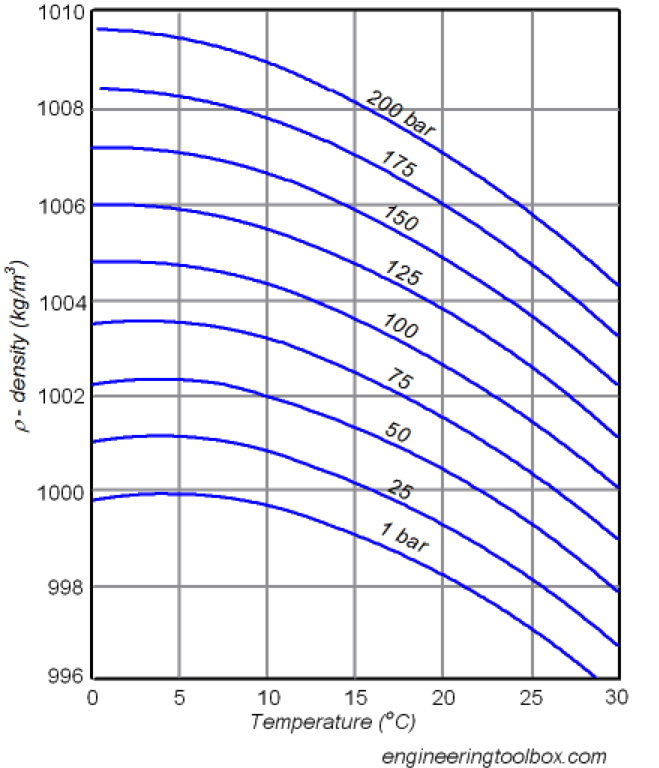
The other part of the question is whether the ocean temperatures will continue to increase, thus causing further thermal expansion. Based on the latest projections, we have no indication that they will stop warming, although of course there is a range of projections. Also, as the question correctly points out, thermal expansion is not the only component of sea-level rise: another large component is the melting of land-based ice. The relevant proportion of these two effects in the total rise in sea-level will change with time, but in all future projections, thermal expansion remains the largest component (Church et al. 2013), unless the Antarctic ice sheets become unstable.
Further reading
Church, J.A., and Coauthors, 2013: Sea-level Change. Climate Change 2013: The Physical Science Basis. Contribution of Working Group I to the Fifth Assessment Report of the Intergovernmental Panel on Climate Change. T.F. Stockar and Coauthors, Eds., Cambridge University Press, Cambridge, United Kingdom and New York, NY, USA.
(a) What are the connectivity issues for coastal environments: the land/sea interface, estuaries and near-shore marine systems? (b) How will ecosystem processes (self-purification, delivery of ecosystem services to adjacent environments etc.) be affected by climate change? (c) What are the direct impacts of climate change on interconnected realms?
November 2016Answered by Melanie Bishop, Associate Professor of Biological Sciences, Macquarie University
Click to view answer
Estuarine and coastal zones are transition zones between land and sea. As low points in the environment to which the land drains, estuaries and coasts are strongly influenced by freshwater, nutrient and sediment inputs from freshwater systems, as well as run-off of nutrients, sediments and pollutants from catchments (Sheaves 2009). Connectivity with the sea determines the extent of saltwater intrusion and tides into estuaries, and the opportunity for larval exchange between estuarine, coastal and marine domains.
Many estuarine and coastal species are dependent on multiple habitats to complete their life cycles (Sheaves 2009). Several species of fish, such as lamprey, salmon and eels, undertake large-scale migrations from freshwater to marine environments, or vice versa, to spawn. Additionally, many aquatic organisms at the larval stage of their life cycle may be transported kilometres, from source to sink populations, by wind, waves and currents.
Processes that enhance or inhibit the flow of organisms and resources between land and sea, and along coastlines, are likely to have large impacts on coastal ecosystems, and the ecosystem services they provide (Sheaves 2009).
Several of the physical impacts of climate change, including sea-level rise, change in rainfall patterns, and altered storminess, may have large effects on estuarine and coastal ecosystems by directly and indirectly modifying connectivity. For example, altered rainfall patterns, coupled with sea-level rise, are expected to result in significant saltwater intrusion of the Kakadu wetland system (BMT WBM 2010). For estuarine habitats, the potential impacts include decreases in the abundance of migratory birds that utilise the area for foraging and breeding, decreases in culturally important fish species such as mud crabs and threadfin salmon, as well as changes in the extent of mangroves (with retraction in some areas and expansion in others; BMT WBM 2010).
In addition, adaptation of human settlements to climate change may influence coastal ecosystems by modifying land-sea connectivity (Bishop et al. in press). In areas of increased rainfall, reservoirs may be built for flood mitigation, while in areas of decreased rainfall, natural flows may be redistributed for agriculture and human consumption. Water retaining structures can serve as barriers to fish migration, unless fish ladders are provided. These barriers can also prevent sediment transport, leading to loss of mudflats and erosion of beaches at downstream, coastal locations. Where water-retaining structures alter the timing, frequency and volume of freshwater flows into the coastal zone, they may interfere with spawning events that are often triggered by changes in salinity and/or flow.
Seawalls, breakwaters, groynes, and barrages built to protect coastal infrastructure from more frequent storm surges and coastal flooding under sea-level rise, can also produce substantive collateral damage to coastal ecosystems by disrupting land-sea and long-shore connectivity of organisms and resources (Bishop et al. in press). For example, these structures may facilitate movement by marine pest species that utilise the increased hard-substrate as a stepping stone for spread. Additionally, dead seaweed has been observed to accumulate on the up-current side of groynes, producing unsightly and odorous banks of decaying material which local authorities have to remove from tourist beaches. This accumulation results in starvation of down-drift beaches of this nutrient source that fuels the productivity of sandy beach ecosystems.
Understanding the mechanisms by which climate change directly and indirectly modifies connectivity is essential if marine spatial planning and green engineering are to be effectively utilised to minimise impacts.
Further reading
Bishop, M.J., and Coauthors, In press: Effects of ocean sprawl on ecological connectivity: impacts and solutions. J. Exp. Mar. Biol. Ecol. (accepted, 29 May, 2016).
BMT WBM, 2010: Kakadu-Vulnerability to Climate Change Impacts. A Report to the Australian Government Department of Climate Change and Energy Efficiency, Australian Government, Canberra. Accessed 20 January 2017. [Available online at: https://www.environment.gov.au/system/files/resources/b2915be6-16e4-4cb3-8533-471ed879bfc1/files/kakadu-coast.pdf].
Sheaves, M., 2009: Consequences of ecological connectivity: the coastal ecosystem mosaic. Mar. Ecol. Prog. Ser. 391, 107-115. Accessed 20 January 2017. [Available online at: http://www.int-res.com/articles/meps2009/391/m391p107.pdf].
How do the risks of losing sand following renourishment compare between a large embayment such as Port Phillip Bay and an east facing ocean beach on the south coast such as that found at Port Fairy? What are the risks/benefits of sourcing sand from approximately 800 m offshore and placing it on the beach as part of a beach renourishment program? How does this affect the overall sand budget of the system?
November 2016Answered by Philip Haines, Managing Director, Water & Environment Group, BMT WBM Pty Ltd
Click to view answer
Sand dynamics in all coastal embayments are driven by the wave climate. Swell waves do not penetrate far into Port Phillip Bay, meaning that the majority of wave action around the Bay foreshores is derived from local winds. This means that the Port Phillip Bay wave climate is characterised by relatively small amplitude and small period waves.
Nourished sand that is placed on the foreshores of Port Phillip Bay will respond to the local wave climate. Given the wave climate is relatively small (compared to open ocean embayments at least), mobilisation and loss of sand after nourishment will likely be limited. If the sand is placed carefully on the beach, cognisant of the wave climate, then losses can indeed be minimised. In contrast, placement of nourished sand on an open coast beach, such as Port Fairy, will be more susceptible to loss given the higher degree of sediment mobility, purely because of the larger wave climate. Again, placement can be designed to roughly match the every-day wave climate, and thus minimise sand loss to a degree. However, if a larger storm occurs, or the dominant wave direction changes for a time, then the beach will respond and nourished sand may be lost more rapidly.
Sourcing of sand for nourishment is a challenge. Nearshore sand is often an alluring option, as transportation costs are low, and the sediment characteristics are usually compatible. However, taking sand from nearshore sand bars may affect the local or regional sand transport processes. Sand is mobilised and transported under the action of waves and tides. Along the Eastern seaboard of Australia, a large wave climate means that sand in water depths of up to 20-30 m can still be mobilised and interact with the coastal processes. Only bigger waves during more severe storm events will mobilise sand in deeper waters, so the occurrence of such mobilisation is relatively infrequent. It is for this reason that offshore sand sourcing in the Gold Coast occurs at depths greater than 30 m. Unfortunately this depth requires special dredgers, generally brought in from overseas.
Offshore dredging could potentially have a significant impact on local and regional sand budgets if it occurs in water depths that are too shallow, that is, where sand is transported from time to time both in cross-shore and alongshore directions. Interruptions to natural sand transport processes through offshore dredging may inhibit the natural on-shore transport of sand, leading to beach recession - especially if the dredged sand is not placed locally. If offshore dredging is proposed as part of a beach nourishment program, it is imperative to have a detailed appreciation of local and regional sand transport processes to ensure that the dredging will not cause secondary impacts on coastal responses.
Another important consideration for beach nourishment of offshore sand reserves is the placement methodology. Options generally are:
i. bottom dumping closer to the beach, but not directly onto the beach;
ii. rainbowing (ejecting in an arc) onto the lower profile of the beach; or
iii. mooring and pumping via pipeline to the upper beach profile.
The costs increase in this order, as does the ‘immediate’ benefit to the beach.
Where do councils sit in terms of insurance and government support for coastal assets damaged in large storm events? For example: Insurers and government leave council high and dry after coastal storm.
December 2016Answered by Donovan Burton, Climate Adaptation Specialist, Climate Planning
Click to view answer
This is a relatively easy question to answer at first – then as with anything associated with climate change it goes down a vortex of complexity. The simple answer of course is ‘it depends’. It depends on the agreement between the insurer and the local government. However, most coastal structures tend to not be covered in general insurance from coastal events (see Bell 2014).
The important thing to take away from your question is the simple fact that councils often do not know much about their risks in regards to their assets and climate change. Councils continue to approve development in coastal areas (including council development) without due consideration of the long-term risks. Councils tend to over-politicise what should be a simple risk management process. This will soon change. The insurance industry is now starting to ask local governments about climate change in a range of insurance contracts and it is likely that in the next few years, climate change will be an expected element in an audit of a local government’s risk register (this is occurring in some parts of Australia already).
Some assets are already uninsurable and this will be exacerbated over time. Insurers will not (and should not) take responsibility for the impact of poor planning and risk management practices. So ultimately the local governments (i.e. the rate payers) may have to foot the bill associated with increased exposure of assets to the effects of climate change.
The disconcerting issue is the fact that Councils have limited ability to generate revenue, may have substantial exposure to risk and in some cases inadequate understanding of the size of their exposure. Insurers will soon be a lever for change (either by working with local governments or by withdrawing insurance for some assets/risk types and/or locations).
Some innovative financing and risk management solutions exist (e.g. catastrophe bonds). While effective examples exist overseas (e.g. New York Metropolitan Transportation Authority and storm surge risk) however, these are yet to materialise with local government here in Australia. I believe that catastrophe bonds and other alternative risk transfer mechanisms have merit and are likely to emerge as more council assets become uninsurable due to the effects of climate change.
In conclusion, some of the assets are probably already uninsurable for acts of the sea and the exposure for councils will increase over time as sea-level rise progresses. For some assets, councils will have to self-insure or explore alternative risk transfer mechanisms and other innovative approaches. Building codes, development standards and planning mechanisms can slowly reduce the risk. However, the best way to overcome this challenge is to get climate change considerations into the ‘DNA’ of the organisation. This will bring about an effective change to risk exposure. Often referred to as climate change governance, the mainstreaming of climate change as an issue is imperative in managing the risk. Some Councils, like Kingborough in Tasmania and Whitsunday Regional Council in Queensland, have policies that ensure that climate change is managed in a consistent and measured way, with appropriate triggers for change embedded into the mechanisms. I recommend that you search their websites for those policies.
Further reading:
Bell, J., 2014: Climate Change and Coastal Development Law in Australia. The Federation Press, Sydney.
Edwards, I., 2014: If my Insurer Says “No”: What Then? Queensland Local Government’s Understanding of Emergent Climate Change Risk and Implications for Risk Transferral Mechanisms. [Unpublished Masters Dissertation]. Griffith University. Brisbane, Australia.
What are the effects of climate change on coastal algal blooms, and how might this affect the Australian fishing industry into the future? Are there any adaptation measures that can help the industry address marine ecological issues such as this?
February 2016Answered by Alistair Hobday, Senior Principal Research Scientist, CSIRO
Click to view answer
Response by Alistair Hobday, Senior Principal Research Scientist, CSIRO, modified from CSIRO response to the Inquiry question described below. Information provided by Peter Thompson (CSIRO) also contributed to this answer.
NB: The active “Inquiry into the impacts of climate change on marine fisheries and biodiversity”, under the Senate Standing References Committee on Environment and Communications, specifically asked for information on changes in the distribution of marine pests and algal blooms. Submissions to the inquiry can be viewed here
Impacts on marine species around Australia have been reported for a range of trophic levels including single-celled marine algae, which are at the base of many marine food chains. For example, in eastern Tasmania, there has been a 50% decline in the biomass of the spring phytoplankton bloom and growth rate (via chlorophyll a) over the period 1997-2007 (Thompson et al. 2009). Even without climate change, the abundance of single-celled species can increase dramatically in some locations, which can result in deleterious effects for local marine ecosystems. In particular, harmful algal blooms are a well-known global phenomena with potentially lethal effects on humans that eat affected seafood. There are more than 80 harmful algal bloom species known from Australian waters (Hallegraeff 2002). The economic impact of harmful algal blooms on the fishing and aquaculture industries can be considerable. The closure of several fisheries along the east coast of Tasmania due to a bloom of Alexandrium tamarense in the spring of 2012 is estimated to have cost upwards of $23 million (Campbell et al. 2013). A prolonged and extensive bloom of A. tamarense along the east coast of Tasmania also occurred in 2015–2016 and contaminated mussels, oysters, scallops and ultimately rock lobsters. Shellfish harvest areas were closed from late July to late November 2015 and some wild fisheries were also closed in 2016. In South Australia blooms of the algae Karenia mikimotoi resulted in major fish kills in 2014, while the algae Chaetoceros sp. bloomed in 2015 in Western Australia with similar results.
There is clear evidence of harmful algal bloom species expanding their range (Thompson et al. 2008) and some expansions are likely related to climate change. There are a number of harmful algal bloom expansions, for fish species the Ciguatera toxin carried by microalgae poses a significant increase in seafood health risks for Australians. In response, Australia has well-developed monitoring programs that ensure harvests are halted when a harmful algal bloom occurs in a region, and thus keep seafood safe to eat. However, the likelihood and magnitude of algal blooms under a changing climate are not well established. The lack of a national risk assessment combined with monitoring largely restricted to regions of known risk potentially exposes Australians and our export markets to novel outbreaks (Campbell et al. 2013).
If blooms of harmful algae increase in the future, fishing industries may be subject to more closures and hence seafood supply will be impacted. Adaptation options that safeguard consumers include real-time monitoring such that fisheries are closed if harmful algal blooms lead to seafood contamination. Forecasts of bloom conditions can also safeguard fisheries and aquaculture by informing harvesting decisions. For example, shellfish harvesters may choose to harvest more at times of year when blooms are rare, and then diversify to other activities during bloom conditions. Forecast systems exist for fish distribution (e.g. Eveson et al. 2015) and are being developed for harmful jellyfish (e.g. Gershwin et al. 2014) and could be developed for Australian coastal algal species if funding was allocated, as demonstrated for some regions of the United States (see NCCOS).
Even non-toxic blooms can lead to fish kills if the levels of oxygen in the water are depleted. Under climate change, with warmer waters, these effects may be magnified. As yet, adaptation options such as “removal of blooms” have not been implemented, and so early warning via forecasting is the only option at this stage. Forecast information may, for example, allow fishers to move to other locations or coastal councils to prepare equipment for rapid removal and disposal of fish kills, and alert coastal users to the cause of fish kills.
Further reading
Campbell, A., D. Hudson, C. McLeod, C. Nicholls, and A. Pointon, 2013: Tactical Research Fund: Review of the 2012 Paralytic Shellfish Toxin Event in Tasmania Associated with the Dinoflagellate Alga, Alexandrium tamarense. FRDC Project 2012/060 Appendix to the final report, SafeFish, Adelaide.
Eveson, J.P., A.J. Hobday, J.R. Hartog, C.M. Spillman, and K.M. Rough, 2015: Seasonal forecasting of tuna habitat in the Great Australian Bight. Fish. Res. 170, 39–49. Accessed on 25 January 2017. [Available online at: http://www.sciencedirect.com/science/article/pii/S0165783615001496].
Gershwin, L., S.A. Condie, J.V. Mansbridge, and A.J. Richardson, 2014: Dangerous jellyfish blooms are predictable. J. R. Soc. Interface 11, 20131168; Published 14 May 2014. Accessed on 25 January 2017. [Available online at: http://rsif.royalsocietypublishing.org/content/11/96/20131168].
Hallegraeff, G.M, 2002: Aquaculturists’ Guide to Harmful Australian Microalgae. School of Plant Science, Hobart.
Thompson, P.A., P.I. Bonham, and K.M. Swadling, 2008: Phytoplankton blooms in the Huon Estuary, Tasmania: top down or bottom up control? J. Plankton Res. 30, 735-753.
Thompson, P.A., M.E. Baird, T. Ingleton, and M.A. Doblin, 2009: Long-term changes in temperate Australian coastal waters: implications for phytoplankton. Marine Ecology Progress Series 394, 1-19.
I get asked quite a bit about the planning horizons for coastal adaptation, particularly related to sea-level rise. Please help me better understand/explain the reasoning behind most planning, engineering and policy decisions being set to the 2100 or 2110 timeframes.
December 2016Answered by Leo Dobes, Crawford School of Economics and Government, ANU, and Professor Jean Palutikof, NCCARF Director
Click to view answer
There is no “correct” or ideal planning horizon for coastal adaptation to sea-level rise (SLR). There is no scientific, economic or engineering reason to use only the 100-year timeframe. It has simply become conventional to do so.
Like most conventions, it is not entirely clear why 100 years has become common usage, but policy makers and modellers do tend to copy each other, mainly because it makes life simpler. One hundred is a nice round number; using it provides comparability with other studies, and one can get away without justifying it on the grounds that everyone else uses it too.
However, there is some underlying rationale for using 100 years. The estimated values and climate effects of the Global Warming Potential (GWP) and Global Temperature change Potential (GTP) concepts used by the IPCC vary depending on timeframes and the different lifetimes of greenhouse gases. The dominant convention nowadays is a 100-year period for GWPs. To ensure consistency in modelling, use of 100-year GWPs or GTPs is generally matched by corresponding estimates of the physical effects and economic implications of climate change over the course of a century. If you want to learn more about GWP and GTP, there is more information here.
Some global climate models are used to project the effects of climate change beyond 100 years. Sea-level rise is projected to be relatively gradual because it depends on many different factors. For this reason, 500-year modelling projections are sometimes used. However, climate model results need to be interpreted in the context of local conditions to be of practical use.
Choice of timeframe ultimately depends on the purpose for undertaking the modelling. Coastal councils would be less likely to require information on sea-level rise or temperature increases beyond 100 years because most infrastructure for which they are responsible has an effective life of a century or less. Roads, for example, are considered by Austroads to have a life of about 20 years, although repairs and maintenance can extend this. NCCARF provides some illustrative information on infrastructure lives and climate change for the UK on page 3 of their Policy Guidance Brief 7, Climate proofing Australia’s infrastructure
Further reading
European Fluorocarbons Technical Committee Factsheet, 2014: Global Temperature Change Potential Compared to Global Warming Potential. 13 May 2014. Accessed 20 January 2017. [Available online at: http://www.fluorocarbons.org/wp-content/uploads/2014/06/efctc-factsheet_gtp.pdf].
NCCARF, 2013: Climate Proofing Australia’s Infrastructure. Policy Guidance Brief 7. NCCARF, Gold Coast. Accessed on 23 January 2017. [Available online at:https://www.nccarf.edu.au/sites/default/files/attached_files_publications/INFRASTRUCTURE_A4-Webview.pdf].
There are many ways in which risk is communicated and even more ways in which it’s interpreted. Engineers use assessments like "design for 1 in 100 years" while climate risk is sometimes used in terminology such as "likelihood" of something happening now, by 2050 or by 2100. These and many other terms confuse the community and the practitioner when delivering projects or information. Are there simple but effective ways all these terms/approaches can be contextualised and communicated to improve understanding?
October 2016Answered by Mark Gibbs, Director of Knowledge to Innovation, QUT
Click to view answer
While more than one Greek philosopher identified with the concept of risk, and that risk would be related to the consequence and the likelihood of an event occurring, the formal definition of risk is often attributed to the French philosopher Blaise Pascal in the late 1600s. Most famous for “Pascal’s Wager”, Pascal defined risk as directly and simultaneously dependent on both the likelihood (commonly expressed as a probability) and the consequence of a hazard occurring. This definition has been enshrined in the international standard ISO 31000 series and is widely used in many technical disciplines, including the engineering and actuarial professions.
For example, the commonly used term of 1-in-100 years expresses the average likelihood of an event occurring, but not the consequence of such an event. Therefore, such terms do not express risk; only likelihood. As an aside, the term 1-in-100 years is now better expressed at the 1% AEP (Annual Exceedance Probability) event.
Unfortunately over the past decade or so, a new generation of climate and natural hazard practitioners and researchers have thought it best to attempt to re-invent the formal definition of risk. The result is exactly what you have identified – there are now multiple definitions being used. My personal view is that this is unhelpful and leads to confusion. My recommendation is therefore that we all stick to the existing, accepted definition that is defined in the international standards (that is, risk=likelihood*consequence).
Having said that, we know that there is widespread lack of understanding among communities on what 1-in-100 years, or 1% AEP, actually means. Some reading on this is as follows.
Further Reading
Gibbs, M.T., 2015: Pitfalls in developing coastal climate adaptation responses. Climate Risk Management. 8, 1-8.
Gibbs, M.T. and H.J. Browman, 2015: Risk assessment and risk management: a primer for marine scientists, ICES J. Marine Sci., 72, 992–996. Accessed on 23 January 2017. [Available online at: https://academic.oup.com/icesjms/article/72/3/992/702340/Risk-assessment-and-risk-management-a-primer-for].
Gibbs, M.T., 2016: Why is coastal retreat so hard to implement? Understanding the political risk of coastal adaptation pathways. Ocean & Coastal Management 130, 107-114. Accessed on 23 January 2017. [Available online at: http://www.tandfonline.com/doi/full/10.1080/10286608.2015.1025385?scroll=top&needAccess=true].
The CHRMAP (coastal hazard risk management and adaptation planning) process within the Western Australian Policy context prescribes a process to understand coastal hazard risks from both inundation and erosion (State Planning Policy 2.6 State Coastal Planning). In terms of erosion, the policy is very limited on how to determine the effect of erosion from either storm surge or sea-level rise. Basically the policy is very focused around Perth and therefore on 'sandy coastlines'. In the north west of Australia, we have a range of alternative coast types, namely 'coastal lowlands' within sheltered areas (e.g. protected by mangroves and large tidal flats). Therefore, the level of risk from erosion in this context is minimal to non-existent. However, the policy position requires that erosion for sea-level rise be determined according to 'sandy coastlines' (e.g. Bruun Rule) and therefore mandates a 90m erosion setback (S3) be added to the erosion hazard lines over the 100-year planning framework. In the context of our environment, the extent of this 'hazard' is not realistic. This is reinforced through the historic observations (S2) which shows a stable, if not accreting coastline over the past 50 years. Therefore, my question is: As the policy prescribes an unrealistic starting point, how much justification is required to outline the erosion hazard as insignificant and rare, and therefore a risk that does not require any further consideration?
October 2016Answered by Philip Haines, Managing Director, Water & Environment Group, BMT WBM Pty Ltd
Click to view answer
Your question raises a few interesting points. Firstly, as a word of caution, historical observations (S2) are not necessarily a good indicator of potential shoreline response to future sea-level (S3), and instead, a more detailed coastal assessment should always be done to understand local coastal processes, including sediment transport, and responses to projected sea-level rise conditions. It is widely recognised in the coastal engineering industry that the ‘Bruun Rule’ is quite restrictive, and not necessarily relevant even on sandy coastlines, especially where there is strong longshore sediment transport and influences on coastal processes from onshore and offshore structures, reefs etc. That said, within the context of CHRMAP, the Bruun Rule has been used to estimate a generic allowance on the WA coast to cater to shoreline recession associated with future sea-level rise (90 m as specified in SPP2.6 Schedule One). But the CHRMAP also mandates the use of a risk-based assessment, meaning that such an allowance is to consider both the likelihood and consequences of such an event occurring. The generic allowance is a simple way to delineate broad spatial planning control area overlays and is often used to raise stakeholders’ awareness of coastal hazards.
The risk assessment process adopted by CHRMAP provides a mechanism for dealing with uncertainties of hazards, through the use of likelihood and consequence scales. Identified hazards that have a low chance of occurring over a nominated timeframe can be assigned as low likelihood within the risk framework. It is always best to provide justification for a decision made within a risk assessment framework, especially with regard to assigning quantified likelihoods or consequences. With respect to the generic 90 m sea-level rise allowance, there is no explicit method provided in the WA policy to quantify the actual likelihood of the hazard. Some examples are provided in the CHRMAP guidelines, but I recommend you seek professional advice on a case-by-case basis and using the best available information to deliver a robust and defensible risk assessment.
With respect to your specific question, if I were in the shoes of the officer administering the State Planning Policy, I would need to be convinced that the likelihood is indeed low in the areas you have suggested. But I would be looking for consideration of the full spectrum of coastal hazards, covering both recession and inundation. So even though the likelihood of shoreline recession due to future sea-level rise may be low in your particular location, the likelihood of increased coastal inundation may actually be high as it is a coastal lowland. If this is the case, you should also be mindful that consequences may be different between recession hazards and inundation hazards. That is, consequences would likely be high if the land was to erode away completely, whereas consequences would probably be lower if the land was only inundated on an occasional basis.
From a policy perspective, use of the mandated 90 m setback provides a level of assurance to the administrator that ‘worst case’ conditions are considered. For greenfield development sites, sensible risk management may advocate an ‘avoidance’ strategy. For sites of existing development though, or where consequences are particularly high, it would be best to proceed with the other components the CHRMAP risk-based process and to seek more detailed investigations to refine definitions of likelihood, consequence and risk based on best available information, science and engineering methods.
Further reading
Government of Western Australia, 2006: State Planning Policy 2.6 State Coastal Planning. Department of Planning, Western Australia Planning Commission. Accessed 19 January 2017. [Available online at: https://www.planning.wa.gov.au/publications/1168.asp].
The City of Greater Geelong Council are evaluating the effectiveness of establishing a near shore semi submersed breakwater to dampen wave energy with the primary objective of preventing further erosion along a vulnerable section of coast near Portarlington, 50km south of Melbourne. The structure will also aim to provide optimum structural habitat for shallow water reef communities. Are any members of the expert panel aware of similar projects that have been trialled in Australia, particularly in waters less than two metres deep that are prone to severe wind derived waves?
September 2016Answered by Mark Gibbs, Director of Knowledge to Innovation, QUT
Click to view answer
Artificial reefs and semi-submerged breakwaters have been used as a means of shore protection for centuries and can be traced back to ancient Egypt. Nearshore shallow water submerged or intertidal structures experienced a resurgence over recent decades as computer models that can predict breaking waves were developed. This enabled such structures to be designed in a way that could also create artificial surfing reefs so that the structures served as shore protection measures and added amenity value.
However, their utility as surfing breaks has been limited, often owing to the lack of precision in construction of these structures (for example, the Narrow neck artificial reef on the Gold Coast). Such structures can be very effective both as shoreline protection measures and as fish attraction devices. The Narrow neck reef, for example, is renowned for attracting biodiversity. To this end, a new such structure is being presently designed for Palm Beach, on the central Gold Coast.
Care must be taken when considering this option as, by design, these structures disrupt sediment transport pathways. Sediment trapped behind these structures, which can help stabilise the beach profile, is potentially sediment that becomes unavailable for shore protection elsewhere. Hence careful consideration of the opportunity cost must be given. Many consultants now offer a numerical (computer) shoreline evolution modelling service. However, these models are still relatively unsophisticated and must be treated with some caution.
There have been attempts to establish less permanent structures to achieve the same end. However, such temporary structures have a habit of coming unstuck even in relatively minor storms.
Further reading
Moore, T., 2016: Palm Beach gets artificial reef in Gold Coast Budget. Brisbane Times. 23 June 2016. Accessed 19 January 2017. [Available online at: http://www.brisbanetimes.com.au/queensland/palm-beach-gets-artificial-reef-in-gold-coast-budget-20160623-gpqkl3.html].
What are the implications for other communities of the recent ruling on Belongil?
August 2016Answered by Ballanda Sack, Special Counsel, Beatty Legal Pty Limited
Click to view answer
Byron Shire Council’s coastal management of Belongil beach has been the subject of litigation initiated at various times by private landowners (in favour of the construction of protective measures) and concerned community groups (opposed to such measures) for well over seven years.
In August this year Council announced that a settlement had been reached between it and owners of land at the beach to resolve a long running Supreme Court case commenced in 2010. Essentially, the case initiated by the landowners alleged negligence on the part of Council in its management of coastal erosion issues at Belongil beach. Specifically, the claims related to the construction of a structure/rock wall intended to protect the southern (main) beach in the 1960s-1970s. This structure was alleged to have caused erosion at Belongil to the north west. Council was also alleged to have been negligent in its ongoing management of the area and specifically in the policies expressed in draft planning instruments and a draft coastal zone management plan prepared in 2009 which gave effect to its policy of “planned retreat”. This policy had the effect of preventing landowners from installing permanent protective measures or maintaining measures already in place.
Early in 2016 Council undertook public consultation for a revised Coastal Zone Management Plan (Draft CZMP) and this plan was lodged with the Minister for Planning for certification under the Coastal Protection Act 1979. The Draft CZMP permits landowner initiated emergency protective measures at Belongil beach and proposes the construction of a seawall at the beach. The estimated construction cost exceeds $14 million, $13 million of which is to be borne by the landowners.
The Draft CZMP has not yet been certified by the Minister. Coastal management in NSW is in a state of reform with a new Coastal Management Act 2016 enacted but not yet in force. Commencement of the legislation is being deferred until the Guidelines and SEPP underpinning the Act have been finalised and undergone public consultation. The new legislation establishes an alternative regime for the preparation of Coastal Management Programs by Council in accordance with the proposed detailed government guidelines. If the Minister certifies the Draft Byron CZMP within six months of the commencement of the Act, then Council will be entitled to act on it until December 2021.
As the matter was settled out of court, it makes no new law and provides no guidance as to how a court might determine a negligence/nuisance claim against a local council in similar circumstances.
The circumstances at Belongil, however, demonstrate the challenges for local government in balancing private property interests with community interests, the complexities of coastal management and the pressures that can be exerted by very well resourced and persistent landowner litigators.
Answered by Sharon Pope, Manager Integrated Planning, Lake Macquarie City Council
Click to view answer
Each case needs to be reviewed on its merits. Existing protective work in one location may be causing accelerated erosion and damage to an adjoining property, or could be causing unacceptable hazards and risks to the public, so removal may be more critical. But if all things were the same as the circumstances surrounding this case, then it indicates that councils should not take steps to remove current protective works, as they currently exist, if this is against the wishes of the property owners who erected the works or those who benefit from them (e.g. subsequent property owners).
If the current protection work is damaged, destroyed, or washed away, the property owners must still follow the usual process to seek approval from the relevant consent authority, and the applicable landowner, for permission to rebuild, repair or replace the works. A full merit assessment would occur to determine whether to grant approval. The ruling maintains the status quo in this regard.
The outcome also indicates that councils should not unreasonably withhold access to their land for the purposes of allowing property owners to carry out approved protection works. Councils may still withhold access if they have a reasonable basis to do so – for example, if the carrying out of the proposed works would unreasonably interfere with public access or give rise to safety concerns. The concept of access not being unreasonably refused is based upon provisions in the New South Wales Coastal Protection Act which provide that a public authority must not unreasonably refuse a person access to public land to enable the person to lawfully place temporary coastal protection works on the land. So this aspect of the outcome also maintains the status quo.
Information provided by CoastExchange moderator
Click to view answer
In addition, Risk Frontiers has published a short article on Belongil Beach and the recent conclusion of two Supreme Court cases concerning Byron Bay property owners. See https://www.riskfrontiers.com/newsletters/RF%20Newsletter_Vol%2016_Issue1_Oct16_web_pdf.pdf
What are the trade-offs that arise from infrastructure that protects the built environment from sea-level rise and the movement of the natural environment? How can adaptation methods for natural environments also be used as adaptation methods to protect infrastructure (i.e. ecosystem buffering)?
July 2016Answered by Alistair Hobday, CSIRO Oceans and Atmosphere
Click to view answer
Infrastructure, such as seawalls, breakwaters, and groynes, can be built to protect coastal assets, such as roads, bridges, housing and other infrastructure from storm surge and sea-level rise. These hard structures can lead to additional geomorphological modification, such as the presence of beaches seaward of seawalls, or the movement of sand behind groynes. These changes may cause loss of public amenity, such as beaches, or increase the rate of erosion if sand supply is interrupted. The use of engineering solutions to protect coastal assets is expensive and so will only be possible when high value assets are in need of protection and there is someone to pay. Coastal protection via engineering structures is controversial, with a range of court battles serving as high profile examples of the conflict between ‘protect’ and ‘retreat’ strategies. Infrastructure can also limit the landward retreat of coastal habitats such as mangroves, saltmarshes, and dunes. Some of these habitats also provide ecosystem services such as coastal protection, carbon sequestration, and recreational opportunities, as well as providing important habitat for protected and fished species.
There is emerging evidence that natural systems can also provide buffering to coastal assets, for both gradual sea-level rise, and extreme events, such as storm surges and even tsunamis (the latter are not climate related). Seagrasses have a particularly high capacity to dissipate wave energy, whereas salt marshes and mangroves have a high capacity to protect from surges. When these ecosystems co-occur, their combined effectiveness in protecting from waves and surges in considerable. However, in cases where erosion is particularly strong and rapid, natural systems may not provide a sufficient buffer, and setting aside land for coastal retreat of these systems may be needed. The relative cost of natural and engineered coastal protection varies depending on the method used to assess the economics, however, natural habitats are considered the most cost-effective in the long run, and over the large coastlines that may need protection.
Further reading
Duarte, C.M., I.J. Losada, I.E, Hendriks, I. Mazarrasa, and N. Marbà, 2013: The role of coastal plant communities for climate change mitigation and adaptation. Nature Climate Change, 3, 961-968.
How do we stimulate a process of re-framing biodiversity objectives so that they are feasible under climate change, reflect society’s values, are ecologically robust and can usefully inform policy and research?
July 2016Answered by Alistair Hobday, CSIRO Oceans and Atmosphere
Click to view answer
We can stimulate a process of reframing by considering timing of decisions, adaptation pathways, and the values, rules, and knowledge that constrain or permit particular decisions and pathways.
As the climate continues to change, the impacts on species and ecosystems will become significant and widespread and many current approaches to conservation will become increasingly difficult and ineffective. The timing of biological changes is not always clear, but we can anticipate which aspects might change and which might persist. This provides the basis of practical approaches for anticipating the implications for biodiversity, and the ecosystem benefits and services that society enjoys (see Dunlop et al. 2013).
Thinking about the timing of decisions along a pathway helps people frame adaptation as a series of decisions over time, instead of a once-off choice (see Stafford Smith et al. 2011). Adaptation options selected now, without considering alternative futures, may become ineffective or even maladaptive in the future. Thinking about decision timing draws people’s attention to the importance of path dependency in adaptation decision-making. This helps people understand how important it can be to take a long-term perspective in order to avoid inadvertently setting out along an undesirable path. The concept of Adaptation Pathways emphasises the importance of both decision timing and decision context, and frames adaptation as the evolution over time of the decision contexts that enable and constrain adaptation decisions (see Wise et al. 2014). Instead of seeing pathways as only a sequence of decisions, the Adaptation Pathways concept helps people view adaptation in terms of the evolution of systems of values, rules, and knowledge. This helps broaden the perspective on adaptation away from narrow framings of decision problems and helps us to understand the importance of uncertainty and learning as integral parts of the adaptation process.
Prevailing systems of societal values, rules and knowledge define the context in which decisions are made (see Gorddard et al. 2016). The interaction of values, rules and knowledge (VRK) both creates and limits the set of decisions that are practical and permissible in a given decision context. This means that successful adaptation may require changes to prevailing systems to enable new decisions to be made. The VRK model can be used to help diagnose constraints in decision processes. This means that adaptation initiatives can be reframed to reveal new approaches to developing adaptation responses to more complex problems.
In some cases, even while societal attitudes may shift, the rules for supporting species adaptation may not be suitable, and so legal frameworks may need to change (see McDonald et al. 2016). An example of developing options for adaptation that are technically suitable, institutionally possible, and socially acceptable has been developed for use with marine species (see Hobday et al. 2015; Alderman and Hobday 2016).
References and further reading
Alderman, R., and A.J. Hobday, 2016: Developing a climate adaptation strategy for vulnerable seabirds based on prioritisation of intervention options. Deep-Sea Res. II: Topical Stud. in Ocean . Accessed 23 January 2017. [Available online at: http://www.sciencedirect.com/science/article/pii/S0967064516301850].
Dunlop M., H. Parris, P. Ryan, F., and Kroon, F 2013: Climate-Ready Conservation Objectives: A Scoping Study. National Climate Change Adaptation Research Facility, Gold Coast, pp. 102. Accessed 19 January 2017. [Available online at: https://www.nccarf.edu.au/publications/climate-ready-conservation-objectives-scoping-study].
Gorddard, R., M.J. Colloff, R.M. Wise, D. Ware, and M. Dunlop, 2016: Values, rules and knowledge: Adaptation as change in the decision context. Environ. Sci. & Policy 57: 60-69. Accessed 23 January 2017. [Available online at: http://www.sciencedirect.com/science/article/pii/S1462901115301210].
Hobday, A.J., and G.T. Pecl, 2014: Identification of global marine hotspots: sentinels for change and vanguards for adaptation action. Rev.Fish Biol. & Fish. 24, 415-425. Accessed 23 January 2017. [Available online at: https://www.researchgate.net/publication/257315797_Identification_of_global_marine_hotspots_Sentinels_for_change_and_vanguards_for_adaptation_action].
Hobday, A.J., L.E. Chambers, and J.P.Y.Arnould, 2015: Prioritizing climate change adaptation options for iconic marine species. Biod. & Cons. 24, 3449-3468. Accessed 23 January 2017. [Available online at: http://link.springer.com/article/10.1007/s10531-015-1007-4].
McDonald, J., P.C. McCormack, A.J. Fleming, R.M.B. Harris, and M. Lockwood, 2016: Rethinking legal objectives for climate-adaptive conservation. Ecol. and Soc. 21, 25. Accessed 23 January 2017. [Available online at: http://www.ecologyandsociety.org/vol21/iss2/art25/].
Stafford Smith, M., L. Horrocks, A. Harvey, and C. Hamilton, 2011: Rethinking adaptation for a 4°C world. Phil. Trans. Roy. Soc. A, Math., Phys. & Eng. Sci., 369, 196-216.
Wise, R. M., I. Fazey, M. Stafford Smith, S.E. Park, H.C. Eakin, E.R.M. Archer Van Garderen, and B. Campbell, 2014: Reconceptualising adaptation to climate change as part of pathways of change and response. Global Env. Change. Accessed 23 January 2017. [Available online at: http://www.sciencedirect.com/science/article/pii/S095937801300232X].
What future roles should local government play to facilitate coastal adaptation? What are the emerging challenges and what legal and institutional measures will help to address the challenges? I would love to hear expert views in both developed and developing country contexts.
July 2016Answered by Sharon Pope, Manager Integrated Planning, Lake Macquarie City Council
Click to view answer
Councils prepare land use strategies, planning controls and policies (such as Local Environmental Plans and Development Control Plans), and make decisions on development proposals. Councils, and Councillors as individuals, have a duty of care and legal obligations to make reasonable decisions, which include consideration of climate change, flooding, coastal processes and sea-level rise.
Councils in NSW also prepare Community Strategic Plans and Resourcing Strategies to prioritise how revenue from rates and grants are spent in each local government area. These plans are prepared with input from the community, and reflect concerns and aspirations of the community. For example, in the Lake Macquarie local government area, we have many people living in low lying, flood prone locations. Those communities expect Council to do flood planning and have policies on acceptable forms of new development in flood prone locations, to build infrastructure to protect areas from tidal inundation, foreshore erosion and to reduce the impacts of poor local drainage on roads and private property. In local government areas where coastal erosion threatens infrastructure and private property, those local communities would also expect their councils to be planning for these risks.
Climate change and sea-level rise are new paradigms for local government – they are hazards or problems with lots of uncertainty. We don’t have complete knowledge of what the impacts will be, when they will occur, and what future technology and societal norms will exist to help manage the impacts and hazards. We call this a complex problem, and we know that complex problems don’t have simple solutions. Local government usually deals with problems that are relatively easy to resolve, where we prepare draft plans or concepts to address a problem, then consult the community to check that we have the right solution. For a complex problem we need to collaborate rather than consult (see http://www.iap2.org for more detail). As the tier of government that is closest to people in the community, as well as being the most accessible and potentially the most transparent, local government is best placed to undertake community collaboration to plan for climate change, flooding, coastal processes and sea-level rise.
In Lake Macquarie City, Council has been using a collaborative approach to prepare sea-level rise adaptation plans. We started with a community who worried that any form of planning would stop them from being about to enjoy the lakeside lifestyle they chose, would cause property values to decline, and insurance premiums to soar. After many discussions, in many forums, as big groups and small groups, we have a plan they support. We still have a community that is worried about property values. However, they realise a plan is necessary for them to be able to enjoy the lakeside lifestyle in the future. They know it is best to plan for the worst and act when necessary (they understand the concept of triggers and thresholds). They also know that not having a plan will allow governments “off the hook”, the burden to be borne only by the affected community. The Marks Point community, where our first plan has been finalised, have so much ownership of the plan they promote it. Since it was prepared, they have sought meetings with State and Federal politicians and agencies, to obtain funding for required protection works, and to ensure legislation doesn’t become a barrier to implementation of the Plan. They also help communicate some of the issues and options for managing risks to other communities when they commence an adaptation plan for their neighbourhood (see here for more detail).
Some of the challenges local governments face relate to the lack of direction and leadership from State and Federal governments. It would definitely help if all tiers of government openly stated that managing the future risks associated with climate change is important and necessary, and that planning needs to start now. Having sea-level rise benchmarks nominated for different coastal regions would allow more consistency in approach (although most councils rely on the CSIRO modelled benchmarks, councils in NSW have all adopted slightly different variations and timeframes for planning purposes). Having a funding source for future protection or retreat plans to be implemented would also assist. At present it isn’t clear who will help fund costly works, and landowners who are directly affected clearly don’t think they should pay the full price for the broader community’s generation of carbon dioxide and other pollutants that are causing climate change. There also needs to be some resolution on what is meant by terms such as current exposure to hazard, future exposure to hazard, coastal flooding, and coastal inundation. Resolution is also required on how to deal with land lost to gradual erosion and sea-level rise, which ceases to be land under the Real Property Act when it falls below Mean High Water Mark (MHWM) – something that will surprise many landowners along the coast.
Answered by Ballanda Sack, Special Counsel, Beatty Legal Pty Limited
Click to view answer
Local government continues to play a critical role in establishing appropriate planning frameworks and promoting resilience and adaptation in the design and placement of buildings and infrastructure.
In responding to the challenges of coastal adaptation, local government’s core function is in providing for adequate community infrastructure (roads, pedestrian walkways, water/sewerage/stormwater infrastructure, sea walls/levies, community facilities and recreational spaces) - this will involve increasingly difficult decisions, especially regarding resource allocation. Frequently, the decisions required to be made by local government are “hard” decisions requiring long-term vision and determination, often in the face of community opposition. Engaging the community in constructive debate concerning coastal adaptation priorities and the balancing of private interests and public rights will be vital to achieving coastal adaption outcomes.
Leadership at the government (state or federal) level in consistently promoting coastal adaptation can significantly assist or impede local governments. A lack of leadership creates a substantial challenge for local government and increases the onus on it to drive community engagement in achieving better coastal adaptation. The availability of resources, both financial and in finding and retaining appropriately trained staff, is always a significant challenge.
To meet the challenges of coastal adaptation, local government needs:
· good information - this includes reliable information on current and predicted impacts (and how these are likely respond to local environmental conditions) as well as information on mitigation and adaption options. It requires confidence that experts are appropriately qualified and reports are to accepted standards;
· a robust, clear and consistent framework for decision making - such a framework needs to include clear government policy promoting coastal adaptation, appropriate enforcement powers and incentives and clarity on balancing private interests and public rights. It must allow for and support a range of adaptation practices and provide a consistent and practicable approach to infill development;
· adequate financial resources and access to appropriately qualified personnel - local government requires certainty that funding will be available in the long term; and
· a “safe” decision-making environment - to make “hard” decisions, local government needs confidence that those decisions made will be protected and supported by the judiciary and government. For instance, appropriately worded statutory indemnities can give comfort to local government that their decisions cannot be challenged where they have acted in good faith and in reliance on appropriate information. They provide an important function in discouraging frivolous litigation and reassuring local government that they will be protected provided proper decision making processes are followed. They also encourage transparency in decision-making.
1a. What are the best practice evaluation principles that adaptation project managers can use to guide development and application of effective evaluation processes to ensure that what is learnt can contribute to the overall knowledge of the adaptation sector? 1b. How can Local Government use information about estimated asset useful life in making no-regret approval and investment decisions in urban areas subject to future climate impacts?
July 2016Answered by Donovan Burton, Climate Planning
Click to view answer
There are a few questions tied up in this “question”. Some easier to answer than others, and with a lack of context I will have to make some assumptions in my response. Firstly, the term “best practice” for anything to do with climate change adaptation is a moving target. The adaptation milieu is still in its infancy and any claims of best practice should be regarded with caution. I’ll replace this with “good practice”.
Response to Question 1a
The most fundamental principle for evaluation to support an increase in the overall knowledge of the adaptation sector is to foster a system that allows the transparent sharing of information. In essence this is what the intention of the CoastAdapt tool is. Climate change adaptation is about informed decision-making and not very much of that seems to occur at the moment. One of the barriers to adaptation is the fact that organisations are too afraid (or sometimes legally constrained) to share information.
There is a great framework called the Collective Impact Model that originated in Stanford (see here). One of the five key principles is related to information management – and I think is relevant to your question:
Shared measurement system: Developing a shared measurement system is essential to collective impact. Agreement on a common agenda is illusory without agreement on the ways success will be measured and reported. Collecting data and measuring results consistently on a short list of indicators at the community level and across all participating organisations not only ensures that all efforts remain aligned, it also enables the participants to hold each other accountable and learn from each other’s successes and failures (Kania & Kramer 2011).
As we are now in the information age it should be reasonably simple to establish systems for the above. Organisations must recognise that data are a critical piece of infrastructure and be prepared to invest in systems and staff that will allow them to implement activities to support adaptation evaluation.
For local governments, protocols can be put in place for monitoring and evaluation (M&E) through climate change adaptation policies (e.g. corporate standards) – see what Kingborough Council (Tasmania) have recently done here. In essence what Kingborough Council are doing is establishing corporate standards around the application of adaptation. This consistent methodology allows for the sharing of consistent information internally. The challenge will be sharing/comparing information with other councils that have differing standards or risk thresholds.
However, systems/frameworks that support shared monitoring and evaluation across jurisdictions and time scales are almost impossible to find. This is why I invented one a couple of years ago, which is being used for over 100 local governments and State Agencies in Australia (see here).
M&E for climate change adaptation is a rapidly evolving space (as is anything to do with climate change). A great resource that highlights the range of M&E principles and methods, written by Dennis Bours and others, can be found here. Actually anything written by Bours on M&E is a great starting point, so I suggest you subscribe to his blog (see here).
Assumption 1: Your question doesn’t seem to focus on an answer for good practice evaluation principles in general – just the ones that ensure that “what is learnt can contribute to the overall knowledge of the adaptation sector”? So I have focussed on that.
Assumption 2: The “adaptation sector” is a very big sector with each having its own specific adaptation process. It can encompass all practitioners of adaptation from local government staff through to designers of agricultural insurance – and everything in between. Given that question 1b refers to local government I have assumed you mean - contribute to the overall knowledge of the “local government” adaptation sector (including those who engage with local governments).
Answer to Question 1b
Everyone wants to make no-regrets approvals and investment decisions; doing so is another matter. Guaranteeing no-regrets is challenging as any decision-making comes with trade-offs, even if you can’t see them in your lifetime (and climate change adaptation is a complex space). What local governments need to do for asset management with a climate change lens is to firstly ensure that they have an internal corporate standard that directs them to minimum information requirements and how that information is used (see my response to question 1a with Kingborough Council’s adaptation policy). Local governments should ensure that climate change is explicitly mentioned in any asset management plans – this then, will link to strategic plans, corporate plans and long term financial management plans. In reality climate change should be in all of these corporate documents.
As I mentioned in the previous response (see 1a), climate change is about informed decision-making. So for asset management, local governments need to ensure that there is an up-to-date spatial inventory of the assets. That may sound like simplistic advice but I know many do not do this. Once a spatial inventory exists, local governments then need to undertake an exposure assessment and quantify how many units (e.g. kilometres of road, number of buildings, etc.) are exposed to differing hazards at differing timescales. Once units are quantified then the cost is usually straight forward, as your organisation will have (or should have) a set replacement value. Once again I direct you to Kingborough Council (Tasmania) as they have done this very thing for the coastal community of Kingston Beach (see here). This quantification process allows the CFO and asset managers to use this information in their existing asset management methods (e.g. for depreciation and maintenance regimes, etc.).
Local governments should also realise that it may not be their assets that present barriers to adaptation – for example in Tasmania water and sewerage are managed by a separate entity. Local governments need to ensure that they are maintaining conversations and collaborations with these and other utilities (e.g. electricity and ICT) as failure to consider climate change in their asset management may limit the ability to service a community in the future.
Also, traditional asset management practices may not be enough. Local governments should also take stock of their green infrastructure, as protecting catchments and the local environment may extend the life of existing assets. A good example of this is how New York saves money and extends the life of existing water treatment facilities by protecting the surrounding ecosystem (see here).
An NCCARF report on local government asset management can be found here.
References and further reading
Balston, J.M., J. Kellett, G. Wells, S. Li, A. Gray, and I. Iankov, 2013, Quantifying the Costs of Climate Change on Local Government Assets, National Climate Change Adaptation Research Facility, Gold Coast, 215 pp. Accessed 19 January 2017. [Available online at: https://www.nccarf.edu.au/sites/default/files/attached_files_publications/Balston_2013_Quantifying_cost_of_climate_change_impacts.pdf].
Bours, D., C. McGinn, and P. Pringle, 2013: Monitoring and Evaluation for Climate change Adaptation: A Synthesis of Tools, Frameworks and Approaches. SEA Change Community of Practice and UKCIP. Accessed 19 January 2017. [Available online at: http://www.ukcip.org.uk/wp-content/PDFs/SEA-change-UKCIP-MandE-review.pdf].
Kania, J. and M. Kramer, 2011: Collective Impact. Stanford Social Innovation Review. Accessed 19 January 2017. [Available online at: https://ssir.org/articles/entry/collective_impact].
Kenny, A., 2006: Ecosystem Services in the New York City Watershed. Ecosystem Marketplace. Accessed 19 January 2017. [Available online at: http://www.ecosystemmarketplace.com/articles/ecosystem-services-in-the-new-york-city-watershed-1969-12-31-2/].
Kingborough Council, 2014: Climate Change Adaptation Policy. Kingborough Council, Tasmania. Accessed 19 January 2017. [Available online at: http://www.kingborough.tas.gov.au/webdata/resources/files/Policy%206.11%20Climate%20Change%20Adaptation%20Policy.pdf].
Kingborough Council, 2015: Kingston Beach Integrated Climate Change and Natural Hazards Project. Kingborough Council, Tasmania. Accessed 19 January 2017. [Available online at: http://www.kingborough.tas.gov.au/webdata/resources/files/KB%20Int%20CC%20NH%20Project%2026%20May%20V1.2%20(23mb).pdf].
Mathew, S., S. Trueck, and C. Truong, 2016: Methods for Evaluation the Results of Monitoring Adaptation Projects and Programs. National Climate Change Adaptation Research Facility, Gold Coast. Accessed 19 January 2017. [Available online at: /how-to-pages/methods-evaluating-results-monitoring-adaptation-projects-and-programs]
Information provided by CoastExchange moderator
Click to view answer
Note from NCCARF: CoastAdapt contains guidance on M&E, and NCCARF has published the results of a short NCCARF-funded research project conducted by Stefan Trueck and colleagues at Macquarie University.
