You are here
Risk assessment - links to external data and visualisation sites
This content provides information on data and visualization sites that are available outside CoastAdapt and that can be drawn on in risk assessments.
At a glance
Climate change risk assessments need to be informed by robust data and information that align with the purpose and scale of the assessment. For high-level assessments it is often sufficient to draw on existing maps and qualitative information, whereas local assessments are likely to require more detailed data to underpin decision-making.
Data needs for risk assessment span climate change scenarios, coastal hazard data, and data on exposed communities, people, infrastructure, natural environments and other assets. Within CoastAdapt, data and visualisation products are available on sea-level rise, coastal compartments and hazard visualisation (see Guide to CoastAdapt Datasets - Coastal sensitivity to flooding and erosion, and Guide to CoastAdapt Datasets - Future sea-level rise and its effects on coastal inundation). Here we identify a range of external data and visualisation sources that can be used for risk assessments.
Main text
Data and visualisation needs for risk assessment
Climate change risk assessments need to be informed by robust data and information that aligns with the purpose and scale of the assessment. For example, high level or first pass assessments that identify and prioritise the range of risks in a region may adequately be supported by national and state mapping tools and qualitative information, whereas a local assessment to underpin a decision on costly and long-life coastal protection infrastructure needs detailed quantitative information and data.
Typically, the data needs for risk assessment span
- climate, including present-day and future climate and sea-level rise
- data to understand coastal hazards
- data to identify risks to communities, people, infrastructure, natural environments and other assets.
Here, we provide information on data and visualisation sites that are available outside CoastAdapt and that can be used for risk assessment. Information on data availability and guidance on use within CoastAdapt is provided in Box 1.
Box 1: Data availability and guidance on use within CoastAdapt
Data and visualisations can be accessed on sea-level rise, flood risk and inundation, and information is provided on coastal geomorphology and coastal currents to support understanding of exposure to risk (see Guide to CoastAdapt Datasets and Information Manual 3: Available datasets).
Guidance on risk assessment, including on use of data, can be found in Guidance on risk assessment, National mapping and coastal risks and C-CADS Step 2 Assess risks and vulnerabilities.
External sources of data useful to understand impacts and assess risk
Climate, including present-day and future climate and sea-level rise
Information on external sources of present-day climate data (terrestrial and oceanic) is provided in Current climate data sources.
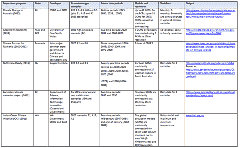
Information on future climate change relevant to different regions in Australia can be obtained from a number of national (e.g. CSIRO and the Bureau of Meteorology (BoM), as well as regional sources (e.g. from state government departments). Table 1 provides details of where information and climate modelling output can be obtained within Australia, and further information can be found at Accessing climate scenarios.
The most up-to-date source of information on future regional sea level change around Australia is CoastAdapt (see Guide to CoastAdapt Datasets).
Table 1: Climate change projection data sources in Australia (all web links accessed 21 May 2016)
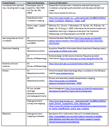
Coastal hazard data and visualisation
Many coastal communities are exposed to one or more hazards from a changing climate, and in some areas the impacts of climate change are likely to be severe. Accessing robust data and information to enable identification of key hazards and affected areas is critical for effective adaptation. Data required by local councils or decision-makers to understand their coastal climate change risks include:
- regional climate change projections
- projected sea level rise and mapping of historic and future areas at risk of coastal inundation
- flood- or fire-prone areas in the local government area or surrounding areas
- floodplain risks from intense rainfall events
- areas exposed to cyclones or east coast lows
- mapping of areas susceptible to erosion and recession.
Key sources of external data and visualisation products are described in Table 2.
Table 2: Data sources for coastal hazards (all web links accessed 21 May 2016).
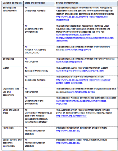
Data and visualisation on risks to coastal assets
A wide range of data is required to understand the risks that coastal hazards from climate change can pose to coastal communities, assets and environments. Data that local councils might need for a climate change risk assessment include:
- property and boundary information in coastal areas exposed to hazard
- type, number and location of major assets and infrastructure
- socio-economic profile of the population in the coastal areas exposed to hazard
- main businesses and facilities operating in the coastal area
- ecosystems, refuges, fauna and flora present, particularly endangered species, ecological communities and assemblages.
Most of this information is likely to be accessible from local or state sources. However, there are a number of datasets managed at the national level which could be useful in a risk and vulnerability assessment. Table 3 provides a summary of relevant national datasets.
Table 3: National data sources relevant to coastal risk assessment (all web links accessed 21 May 2016).